IMAGES TAKEN NEAR TO
Meriden Street, COVENTRY, CV1 4DL
Introduction
This page details the photographs taken nearby to Meriden Street, CV1 4DL by members of the Geograph project.
The Geograph project started in 2005 with the aim of publishing, organising and preserving representative images for every square kilometre of Great Britain, Ireland and the Isle of Man.

There are currently over 7.5m images from over14,400 individuals and you can help contribute to the project by visiting https://www.geograph.org.uk
Image Map
Images are licensed for reuse under creativecommons.org/licenses/by-sa/2.0
Notes
- Clicking on the map will re-center to the selected point.
- The higher the marker number, the further away the image location is from the centre of the postcode.
Image Listing (192 Images Found)
Images are licensed for reuse under creativecommons.org/licenses/by-sa/2.0
Image
Details
Distance
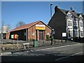
1
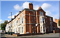
Coundon Road houses at Middleborough Road junction
There is an Ordnance Survey benchmark Image on the chimney breast of the nearest house.
Image: © Roger Templeman
Taken: 19 Sep 2017
0.06 miles
3
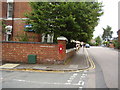
Victorian Post Box, Coundon Street
Situated on the junction with Coundon Road.
Image: © Anthony Vosper
Taken: 18 Aug 2012
0.06 miles
4
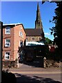
Coventry-Saint Osburg's Roman Catholic Church
A view of the church from Coundon Road.
Image: © Ian Rob
Taken: 7 Mar 2011
0.06 miles
5
Coventry-Upper Hill Street
The Gospel Hall on the corner of Abbotts Lane
Image: © Ian Rob
Taken: 7 Mar 2011
0.06 miles
6
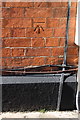
Benchmark on #26 Coundon Road, on Middleborough Road face
Ordnance Survey cut mark benchmark described on the Bench Mark Database at www.bench-marks.org.uk/bm75905
Image: © Roger Templeman
Taken: 19 Sep 2017
0.06 miles
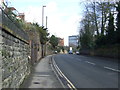
7
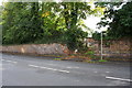
Gateway in wall on SE side of Barras Lane
There is an Ordnance Survey benchmark Image on the wall about 1m left of the gates
Image: © Roger Templeman
Taken: 19 Sep 2017
0.07 miles
8
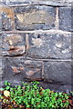
Benchmark on wall on SE side of Barras Lane
Ordnance Survey cut mark benchmark described on the Bench Mark Database at www.bench-marks.org.uk/bm89064
Image: © Roger Templeman
Taken: 19 Sep 2017
0.07 miles
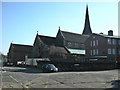
9
Catholic Church of The Most Holy Sacrament and St Osburg, Coventry
This is the mother church of modern Catholic Coventry. The photo has been taken from across Barras Lane to the north. To the left can be seen the presbytery (priest's house), which was built around 1960 to replace a predecessor that was destroyed in the second world war. It is known as the Priory, a monastic term; the parish was run by Benedictine monks until 1992. To the right among the trees can be seen the church primary school.
A small brick chapel was built on this site in 1807 by the Benedictines. The present church building opened in 1844. The architect was Charles Hansom, who toured Gothic churches in Germany and Belgium to gain inspiration. He chose an 'Early English' Gothic style with tall, narrow pointed windows (lancets), and a rugged granite as a building material. It was dedicated to St. Osburg, an 11th century abbess in Coventry. The church was damaged in the November 1940 air raid and subsequently restored. https://taking-stock.org.uk/building/coventry-the-most-holy-sacrament-and-st-osburg/
Image: © A J Paxton
Taken: 12 Jun 2021
0.07 miles
10
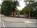
Former entrance to Bablake School
The driveway remains but the main gate has been removed and blocked up.
Image: © Anthony Vosper
Taken: 18 Aug 2012
0.07 miles