IMAGES TAKEN NEAR TO
Sandy Lane, COVENTRY, CV1 4BE
Introduction
This page details the photographs taken nearby to Sandy Lane, CV1 4BE by members of the Geograph project.
The Geograph project started in 2005 with the aim of publishing, organising and preserving representative images for every square kilometre of Great Britain, Ireland and the Isle of Man.

There are currently over 7.5m images from over14,400 individuals and you can help contribute to the project by visiting https://www.geograph.org.uk
Image Map
Images are licensed for reuse under creativecommons.org/licenses/by-sa/2.0
Notes
- Clicking on the map will re-center to the selected point.
- The higher the marker number, the further away the image location is from the centre of the postcode.
Image Listing (108 Images Found)
Images are licensed for reuse under creativecommons.org/licenses/by-sa/2.0
Image
Details
Distance
1
Widdrington Court private car park on Widdrington Road
This site used to house a garage and small petrol station. You can see where the pavement has been lowered for cars to enter and leave the forecourt of the former petrol station. The houses in the background are in Somerset Road.
Image: © starkderrick
Taken: 10 Oct 2011
0.06 miles
2
Houses at junction of Ellys Road and St Nicholas Street
There is a footpath over the railway leading from the end of the road at the left hand side of the image. There is an OS benchmark Image on the right hand side of the near house (#1 Ellys Road), near its front corner
Image: © Roger Templeman
Taken: 12 Feb 2018
0.06 miles
3
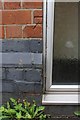
Part of benchmark on #1 Ellys Road
Ordnance Survey cut mark benchmark described on the Bench Mark Database at http://www.bench-marks.org.uk/bm92981
Image: © Roger Templeman
Taken: 30 Apr 2018
0.06 miles
4
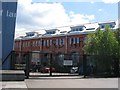
Turbine building Electric Wharf
The converted turbine house of Coventry's Victorian electric power station at Electric Wharf, viewed from the Sandy Lane side.
Image: © E Gammie
Taken: 12 May 2012
0.08 miles
5
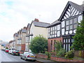
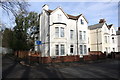
Ellys Rd
Ellys Rd is a short residential road between Sandy Lane and St Nicholas St. This is the view east and the half timbered mock Tudor house on the right is called Ickleford.
Image: © Nigel Mykura
Taken: 13 Aug 2010
0.09 miles
6
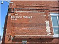
Electric Wharf, Turbine wall
The buildings from Coventry's Victorian electric power station in Sandy Lane were retained when the site was converted to a mixed use residential and business site known as Electric Wharf. This is the end wall of the turbine house and the text reads:
"Resolved that application be made to the Board of Trade for a provisional order under the Electric Lighting Acts 1882 and 1888 authorising the Mayor, Aldermen and Citizens of Coventry to create and maintain Electric Lines and produce, store, supply and distribute Electricity for public and private purposes within the City of Coventry and that all proceedings heretofore taken in that behalf be confirmed.
10 February 1891 City of Coventry Resolution"
Image: © E Gammie
Taken: 12 May 2012
0.10 miles
7
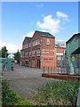
Faraday building, Electric Wharf
Part of the old electricity generating plant, now converted to a mix of commercial offices, live-work space and apartments. Viewed from the footpath by the canal.
Image: © E Gammie
Taken: 12 May 2012
0.11 miles
8
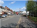
Sandy Lane
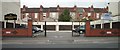
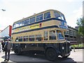
Early 20th century terraced housing and shops on the left, industrial units on the right. The land to the right was originally occupied by Daimler and is where the first British produced Daimler car was made in 1897.
The bus, a 1945 Daimler CWD6 (registration VV8934), is approaching the entrance to the former Coventry Transport Sandy Lane bus garage (where the people are standing) where it will put down/pick up passengers being shuttled between there and the Transport Museum as part of a Coventry City Transport centenary bus rally.
Image: © E Gammie
Taken: 12 May 2012
0.11 miles
9
Ladywood bus at Sandy Lane
A visiting former Birmingham City Transport Guy Arab IV bus from c. 1950 (registration JOJ548) awaiting passengers to ferry back to the city centre from the entrance to the former Sandy Lane bus garage. One of several buses on display at a Coventry Transport Museum open stores day and celebration of Coventry Transport bus centenary.
Image: © E Gammie
Taken: 12 May 2012
0.11 miles
10
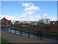
Electric Wharf, Coventry Canal
The industrial looking buildings round the bend of the canal are the former Coventry electricity generating plant, dating from the late 19th century. It has been refurbished in recent years and converted to a variety of live-work spaces and apartments, known collectively as Electric Wharf.
Image: © E Gammie
Taken: 12 May 2012
0.11 miles