
IMAGES TAKEN NEAR TO
Spon End, COVENTRY, CV1 3HF
Introduction
This page details the photographs taken nearby to Spon End, CV1 3HF by members of the Geograph project.
The Geograph project started in 2005 with the aim of publishing, organising and preserving representative images for every square kilometre of Great Britain, Ireland and the Isle of Man.

There are currently over 7.5m images from over14,400 individuals and you can help contribute to the project by visiting https://www.geograph.org.uk
Image Map
Images are licensed for reuse under creativecommons.org/licenses/by-sa/2.0
Notes
- Clicking on the map will re-center to the selected point.
- The higher the marker number, the further away the image location is from the centre of the postcode.
Image Listing (321 Images Found)
Images are licensed for reuse under creativecommons.org/licenses/by-sa/2.0
Image
Details
Distance
1
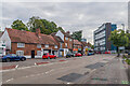
Spon End
Looking along Spon End to its junction with Upper Spon Street (on the left) and Butts Road (off to the right). The row of houses on the left are of various ages, mainly 17th Century but with 19th Century frontages, and most are listed, either by Historic England or locally. A blue plaque on no 102, the tall building in the centre of the row, reads: "W H Christie Watch case maker and movement cap maker 1896 - 1909".
In the background is the 1960 Spon Gate House
Image: © Ian Capper
Taken: 24 Sep 2021
0.00 miles
2
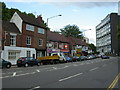
Spon End, shops
Former post office, two take-aways, fish and chips, martial arts, barber and café; the building with a blue plaque was once a watch and clock maker's.
Image: © Mike Faherty
Taken: 3 Jul 2010
0.01 miles
3
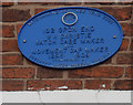
Coventry Watch Museum Project plaque on 102 Spon End
One of the 20 plaques on the Coventry Watch Museum Heritage Trail
Image: © 360Libre
Taken: 19 Jan 2018
0.01 miles
4
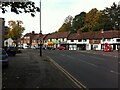
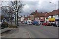
Historic houses, Spon End
The settlement of Spon developed to the west of the city of Coventry in the Middle Ages. It is mentioned in the early 13th century, while the Spon Bridge over the Sherbourne (off to the right of this photo) is known to have been in existence by the end of the century; see the Victoria County History of Warwickshire vol 8 pp1-23 https://www.british-history.ac.uk/vch/warks/vol8/pp1-23 . Now known as Spon End, the area preserves many buildings from the 17th century or earlier; see the Historic England website here https://historicengland.org.uk/listing/the-list/list-entry/1076600 . Some of these houses are seen here from near the junction of Spon End with Butts Road, with the Dyers' Arms public house to the left.
Image: © A J Paxton
Taken: 9 Oct 2021
0.01 miles
6
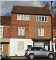
Coventry Watch Museum Project site of plaque on 102 Spon End
This is a typical watchmakers house of this period - late 19thC. At the rear there is a "top shop" with large windows to enable the watch makers to carry out their trade.
W.H. Christie made watch cases and movement caps here in the late 19th C.
A close up the plaque can be seen here Image
Image: © 360Libre
Taken: 16 Feb 2018
0.01 miles
7
Spon End
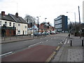
The cream coloured building on the left is the former Malt Shovel public house which traded from 1808 to 2008. Most of the group of buildings beyond date from the 17th century and are grade II listed. The flats were constructed in 1961 and are sandwiched between Spon Street to the left, the Butts to the right and the river Sherbourne beyond. Several blocks of this design were built in or near the city centre in the early 1960s.
Until drainage improvement works were completed in the 1960s/70s this area was regularly subject to flooding from the Sherbourne (which runs behind the houses) backing up at the Spon Street bridge.
Image: © E Gammie
Taken: 16 Jan 2011
0.02 miles
8
Spon End
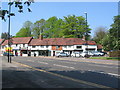
The houses shown here are two groups which appear in the National Heritage List as 107-110 and 111-116 Spon End, dating from the 17th century or earlier and grade II listed. The river Sherbourne runs behind the houses and the start of the parapet of Spon Street bridge over the river can be seen on the right.
Although the road in the foreground is clear of traffic, it is actually a busy road (B4101) and it took a while to catch a gap coinciding with the nearby traffic light sequences.
In 1972: Image]
Image: © E Gammie
Taken: 12 May 2016
0.02 miles
9
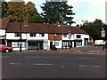
111-116 Spon End, Coventry
The settlement of Spon developed to the west of the city of Coventry in the Middle Ages. It is mentioned in the early 13th century, while the Spon Bridge over the Sherbourne, visible at the right of this photo, is known to have been in existence by the end of the century; see the Victoria County History of Warwickshire vol 8 pp1-23 https://www.british-history.ac.uk/vch/warks/vol8/pp1-23 . Now known as Spon End, the area preserves many buildings from the 17th century or earlier. This row of house was given Grade II listed status in 1974; see the Historic England website here https://historicengland.org.uk/listing/the-list/list-entry/1076600 .
Image: © A J Paxton
Taken: 9 Oct 2021
0.02 miles
10
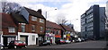
Spon End
Housing in Spon End is mixed with the medieval shops and houses contrasting with the tower block.
Image: © Keith Williams
Taken: 1 Mar 2007
0.02 miles