IMAGES TAKEN NEAR TO
Westminster Road, COVENTRY, CV1 3DL
Introduction
This page details the photographs taken nearby to Westminster Road, CV1 3DL by members of the Geograph project.
The Geograph project started in 2005 with the aim of publishing, organising and preserving representative images for every square kilometre of Great Britain, Ireland and the Isle of Man.

There are currently over 7.5m images from over14,400 individuals and you can help contribute to the project by visiting https://www.geograph.org.uk
Image Map (Loading...)


Getting Data...Please wait
Leaflet Map data © OpenStreetMap
Images are licensed for reuse under creativecommons.org/licenses/by-sa/2.0
Notes
- Clicking on the map will re-center to the selected point.
- The higher the marker number, the further away the image location is from the centre of the postcode.
Image Listing (390 Images Found)
Images are licensed for reuse under creativecommons.org/licenses/by-sa/2.0
Image
Details
Distance
1
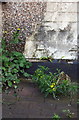
Benchmark on #7 Westminster Road
Ordnance Survey cut mark benchmark described on the Bench Mark Database at http://www.bench-marks.org.uk/bm75788
Image: © Roger Templeman
Taken: 3 May 2016
0.04 miles
2
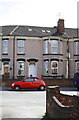
#7 Westminster Road
There is an OS benchmark Image in the bricks on the front of the house where the pebbledash has broken away from the wall left of the downpipe
Image: © Roger Templeman
Taken: 3 May 2016
0.04 miles
3
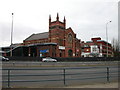
Coventry Queens Road
Queens Road Baptist Church,as seen from the Ring Road.
Image: © Ian Rob
Taken: 15 Dec 2006
0.06 miles
4
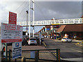
Central Six retail park beyond a footbridge, Coventry
The footbridge crosses the site and the railway, connecting Grosvenor Road on the north side with Spencer Park and Spencer Avenue on the south side.
Image: © Robin Stott
Taken: 19 Dec 2014
0.07 miles
5
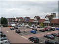
Central Six shopping - Coventry, West Midlands
A view from the pedestrian overbridge of the Central Six shopping park in Coventry. The tower block in the background is the Ramada Hotel. Time photo taken 1.44 pm BST (British Summer Time).
Image: © Martin Richard Phelan
Taken: 22 Aug 2017
0.07 miles
6
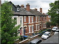
Over Grosvenor Road - Coventry, West Midlands
A view of houses in Grosvenor Road taken from the pedestrian overbridge linking Spencer Park, Earlsdon with the Central Six shopping park. These are, I assume, are of Victorian date with the distinctly more modern additions of cars and wheelie bins. Time photo taken 1.38 pm BST (British Summer Time).
Image: © Martin Richard Phelan
Taken: 22 Aug 2017
0.07 miles
7
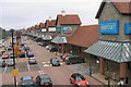
Central Six Retail Park, Coventry
View of Central Six Retail Park taken from the pedestrian bridge. Big names on the park include Hobbycraft, Outfit, Next, TK Maxx, Gap, and Boots.
Image: © Niki Walton
Taken: 12 Oct 2007
0.07 miles
8
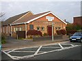
Coventry-Christadelphian Hall
Tucked away in Grosvenor Road.
Image: © Ian Rob
Taken: 16 Nov 2007
0.07 miles
9
Coventry-Grosvenor Road
The old footbridge joins the newer "Anarchy bridge" across Central Six Shopping Complex and the railway into Spencer Park.
Image: © Ian Rob
Taken: 23 Jan 2011
0.07 miles
10
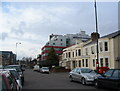
Queen's Road
A bizarre mixture of building styles and dates. Mainly offices and student residences, with the eaves of the former Hen and Chickens (now Aardvark) public house visible beyond the white van.
Image: © E Gammie
Taken: 16 Jan 2011
0.07 miles