IMAGES TAKEN NEAR TO
Basin Bridge Lane, NUNEATON, CV13 6JJ
Introduction
This page details the photographs taken nearby to Basin Bridge Lane, CV13 6JJ by members of the Geograph project.
The Geograph project started in 2005 with the aim of publishing, organising and preserving representative images for every square kilometre of Great Britain, Ireland and the Isle of Man.

There are currently over 7.5m images from over14,400 individuals and you can help contribute to the project by visiting https://www.geograph.org.uk
Image Map
Images are licensed for reuse under creativecommons.org/licenses/by-sa/2.0
Notes
- Clicking on the map will re-center to the selected point.
- The higher the marker number, the further away the image location is from the centre of the postcode.
Image Listing (16 Images Found)
Images are licensed for reuse under creativecommons.org/licenses/by-sa/2.0
Image
Details
Distance
1
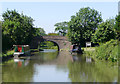
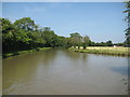
The Ashby Canal near Higham on the Hill, Leicestershire
Approaching Basin Bridge (No 22).
Image: © Roger D Kidd
Taken: 16 Jun 2010
0.14 miles
2
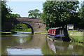
Basin Bridge near Higham on the Hill, Leicestershire
Bridge No 22 on the Ashby Canal as it approaches Stoke Golding.
The canal is a very popular one for boaters because (at present) it has twenty-two miles with no locks to negotiate, and is mainly through rural and attractive countryside. It was opened in 1804, but never reached its intended destination of Ashby-de-la-Zouch. Active effort is now being made to extend the canal beyond its present limit at Snarestone.
Image: © Roger D Kidd
Taken: 16 Jun 2010
0.14 miles
3

Basin Bridge south of Stoke Golding, Leicestershire
Bridge No 22 on the Ashby Canal, which also happens to be twenty-two miles long (at present), with no locks to impede the progress of the less energetic navigators. Opened in 1804.
Image: © Roger D Kidd
Taken: 16 Jun 2010
0.14 miles
4
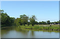
The Ashby Canal south of Stoke Golding, Leicestershire
The canal appears very wide in the image because the foreground includes part of the large winding hole north of Basin Bridge. Could this be the origin of the name Basin here? There is no real canal basin nearby.
Image: © Roger D Kidd
Taken: 16 Jun 2010
0.14 miles
5
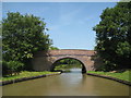
Ashby Canal: Bridge Number 22
Bridge Number 22 is Basin Bridge and takes Basin Bridge Lane over the canal. It probably dates from no later than 1804 when the canal was built. Unlike several other bridges on the canal it does not merit Grade II Listing status.
Image: © Nigel Cox
Taken: 11 Jul 2013
0.15 miles
6
Ashby Canal: Basin Bridge Winding Hole
A winding hole is a short widened reach of canal that enables long narrowboats to be turned through 180 degrees. This one is shown on the earliest currently available edition of the large scale Ordnance Survey mapping from 1888, and is just to the north of Image
Image: © Nigel Cox
Taken: 11 Jul 2013
0.15 miles
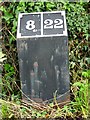
7
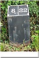
Old milemarker by the Ashby Canal, Basin Bridge
Milemarker by the Ashby Canal, in parish of Higham on the Hill (Hinckley and Bosworth District), Basin Bridge, 50m South of Bridge 22.
Inscription reads:-
8|22
(To Marston Junction and Moira)
Surveyed
Milestone Society National ID: ASH-08
Image: © Milestone Society
Taken: Unknown
0.15 miles
8
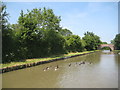
Ashby Canal: Reach near Higham on the Hill
A flock of 14 Canada Geese head off purposefully towards Image
Image: © Nigel Cox
Taken: 11 Jul 2013
0.15 miles
9
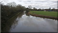
Ashby Canal
The Ashby canal is captured here south of Stoke Golding.
Image: © Peter Mackenzie
Taken: 21 Feb 2017
0.16 miles
10
Milepost 8 on the Ashby Canal
One of a series of similar mileposts on the Ashby Canal.
The canal never reached Ashby-de-la-Zouch and only the southern part of the canal is navigable today.
Image: © Mike W Hallett
Taken: 2 Aug 2009
0.16 miles