IMAGES TAKEN NEAR TO
Station Road, NUNEATON, CV13 6EZ
Introduction
This page details the photographs taken nearby to Station Road, CV13 6EZ by members of the Geograph project.
The Geograph project started in 2005 with the aim of publishing, organising and preserving representative images for every square kilometre of Great Britain, Ireland and the Isle of Man.

There are currently over 7.5m images from over14,400 individuals and you can help contribute to the project by visiting https://www.geograph.org.uk
Image Map (Loading...)


Getting Data...Please wait
Leaflet Map data © OpenStreetMap
Images are licensed for reuse under creativecommons.org/licenses/by-sa/2.0
Notes
- Clicking on the map will re-center to the selected point.
- The higher the marker number, the further away the image location is from the centre of the postcode.
Image Listing (46 Images Found)
Images are licensed for reuse under creativecommons.org/licenses/by-sa/2.0
Image
Details
Distance
1
The George & Dragon, Stoke Golding
The old centre of Stoke Golding is not short of pubs - this one in the distinctive and cheerful colours of Ansell's Brewery.
Image: © Stefan Czapski
Taken: 23 Jan 2011
0.05 miles
2
Stoke Golding: Crown Hill
Reputedly somewhere near this location Henry Tudor was crowned King Henry VII of England following his success at the Battle of Bosworth on 22 August 1485, and thus the Tudor dynasty began.
Image: © Nigel Cox
Taken: 11 Jul 2013
0.07 miles
3
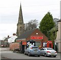
Stoke Golding Post Office
Located along the High Street next to the George & Dragon Public House. St Margaret's Church is visible behind the post office.
Image: © Mat Fascione
Taken: 26 Jan 2008
0.08 miles
4
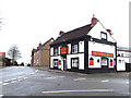
The George & Dragon, Stoke Golding
A public house at the junction of Main Street, High Street, and Station Road.
Image: © Mat Fascione
Taken: 26 Jan 2008
0.08 miles
5
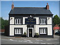
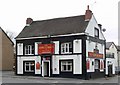
Stoke Golding: The George and Dragon
Occupying a prominent position in the village at the junction of the High Street, Station Road and Main Street this public house has evidently had a change of ownership since Stefan photographed it in January 2011 Image Gone are the bright red Ansell's nameboards to be replaced by the more sober (if that is possible with a pub) colours of the Church End Brewery.
Image: © Nigel Cox
Taken: 11 Jul 2013
0.09 miles
6
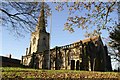
St Margaret's Stoke Golding
South Aisle of 1280, chancel rebuilt in 1882 with raised roof line
Image: © Chris Stafford
Taken: 21 Nov 2006
0.09 miles
7
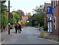
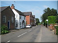
Horse rider on Station Road in Stoke Golding
Image: © Mat Fascione
Taken: 18 Aug 2013
0.09 miles
8
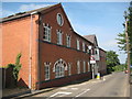
Stoke Golding: Station Road hosiery factory
The old Ordnance Survey map of 1888 shows a hosiery factory on this site, although the current building is distinctly Edwardian in design and much larger than its Victorian counterpart.
Image: © Nigel Cox
Taken: 11 Jul 2013
0.09 miles
9
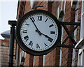
Clock on former hosiery factory
See Image also.
Image: © Andrew Tatlow
Taken: 8 Sep 2016
0.09 miles
10
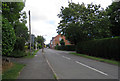
Station Road/Higham Lane Junction
The large building in the distance to the right is a former hosiery factory now converted to flats; the former factory retains its prominent clock.
See Image
Image: © Andrew Tatlow
Taken: 8 Sep 2016
0.10 miles