IMAGES TAKEN NEAR TO
Barton Road, NUNEATON, CV13 0EP
Introduction
This page details the photographs taken nearby to Barton Road, CV13 0EP by members of the Geograph project.
The Geograph project started in 2005 with the aim of publishing, organising and preserving representative images for every square kilometre of Great Britain, Ireland and the Isle of Man.

There are currently over 7.5m images from over14,400 individuals and you can help contribute to the project by visiting https://www.geograph.org.uk
Image Map
Images are licensed for reuse under creativecommons.org/licenses/by-sa/2.0
Notes
- Clicking on the map will re-center to the selected point.
- The higher the marker number, the further away the image location is from the centre of the postcode.
Image Listing (16 Images Found)
Images are licensed for reuse under creativecommons.org/licenses/by-sa/2.0
Image
Details
Distance
1
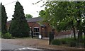
Barlestone Church of England Primary School
Image: © Andrew Tatlow
Taken: 24 May 2006
0.09 miles
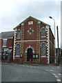
7
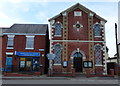
Baptist Chapel in Barlestone
Located along West End, it was constructed in 1865.
Image: © Mat Fascione
Taken: 16 Jun 2013
0.12 miles
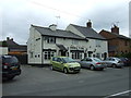
9
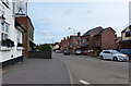
Newbold Road in Barlestone
On the left is the Elohim Church Hub, formerly the Jolly Toper public house.
Image: © Mat Fascione
Taken: 16 Jun 2013
0.14 miles