IMAGES TAKEN NEAR TO
Gulson Road, COVENTRY, CV1 2JF
Introduction
This page details the photographs taken nearby to Gulson Road, CV1 2JF by members of the Geograph project.
The Geograph project started in 2005 with the aim of publishing, organising and preserving representative images for every square kilometre of Great Britain, Ireland and the Isle of Man.

There are currently over 7.5m images from over14,400 individuals and you can help contribute to the project by visiting https://www.geograph.org.uk
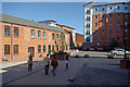
Image Map
Images are licensed for reuse under creativecommons.org/licenses/by-sa/2.0
Notes
- Clicking on the map will re-center to the selected point.
- The higher the marker number, the further away the image location is from the centre of the postcode.
Image Listing (146 Images Found)
Images are licensed for reuse under creativecommons.org/licenses/by-sa/2.0
Image
Details
Distance
1
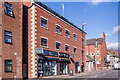
Gulson Lodge
Small retail/apartment block on Gulson Road built in the late 2010s.
Image: © Ian Capper
Taken: 24 Sep 2021
0.04 miles
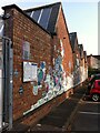
2
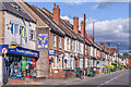
Gulson Road
Early 20th Century housing in Gulson Road, first shown on the 1914 25 inch map. The shop on the corner is the former Hare and Hounds pub which moved here around 1906 from a previous site on Far Gosford Road. The original building here was destroyed by a bomb in 1940, and was replaced by the present building after the war. It closed in 2006, with use changing to a corner shop.
Image: © Ian Capper
Taken: 24 Sep 2021
0.05 miles
3
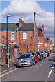
David Road
Early 20th Century street linking Charterhouse Road and St Margaret Road, connecting the end of Carmelite Road and Monks Road, the houses seen here.
Image: © Ian Capper
Taken: 24 Sep 2021
0.07 miles
4
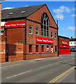
Buildbase Hirebase Electricbase in Coventry
Viewed across Gulson Road.
Image: © Jaggery
Taken: 18 Apr 2015
0.08 miles
5
Callice Court
Student accommodation, opened in 2007, accessed from Far Gosford Street.
Image: © Stephen McKay
Taken: 23 May 2010
0.08 miles
6
Exit from Fargo Village onto Grafton Street, Coventry
Or the entrance from Grafton Street, if you are coming that way to Fargo Village, a bohemian business centre on Far Gosford Street, from which it takes its name. The premises on the right area PopBangColour, the studio of an artist, Ian Cook, who paints using radio-controlled model cars. https://www.popbangcolour.com/about-1
Image: © A J Paxton
Taken: 24 Jul 2021
0.09 miles
7
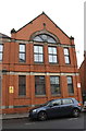
The Parish Rooms, Vecqueray Street
There is an Ordnance Survey benchmark Image on the front of the former church hall at its right hand corner, visible in the gap between the two parked cars
Image: © Roger Templeman
Taken: 8 Aug 2017
0.09 miles
8
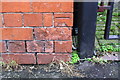
Benchmark on The Parish Rooms, Vecqueray Street
Ordnance Survey cut mark benchmark described on the Bench Mark Database at www.bench-marks.org.uk/bm65686
Image: © Roger Templeman
Taken: 8 Aug 2017
0.09 miles
9
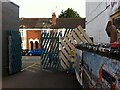
Factory wall, now part of Fargo Village retail development, Far Gosford Street, Coventry
Wall of an early 20th century factory, which now forms part of the Fargo Village 'creative quarter', which opened in 2014. https://www.coventrysociety.org.uk/news/article/fargo-village.html According to a wall plaque on the site, the factory was built in 1904 for making radiators for cars. The motor industry was certainly becoming established in the area at that time, with Calcott's factory at the city end of Far Gosford Street and Humber at the eastern, Stoke end.
Image: © A J Paxton
Taken: 24 Jul 2021
0.10 miles
10
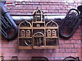
I'm only a Horn in a Wooden Cage
Sculpture, untitled, displayed on the inside of the market hall at Fargo Village, Coventry; the top of FARGO lettering is visible below. A cornet can be seen inside an elaborate architectural birdcage, flanked by larger brass instruments painted a dark greyish shade. The photo was taken in June 2018; the artwork is no longer on display there.
Image: © A J Paxton
Taken: 9 Jun 2018
0.10 miles