IMAGES TAKEN NEAR TO
Newtown Road, BEDWORTH, CV12 8QG
Introduction
This page details the photographs taken nearby to Newtown Road, CV12 8QG by members of the Geograph project.
The Geograph project started in 2005 with the aim of publishing, organising and preserving representative images for every square kilometre of Great Britain, Ireland and the Isle of Man.

There are currently over 7.5m images from over14,400 individuals and you can help contribute to the project by visiting https://www.geograph.org.uk
Image Map
Images are licensed for reuse under creativecommons.org/licenses/by-sa/2.0
Notes
- Clicking on the map will re-center to the selected point.
- The higher the marker number, the further away the image location is from the centre of the postcode.
Image Listing (4 Images Found)
Images are licensed for reuse under creativecommons.org/licenses/by-sa/2.0
Image
Details
Distance
1
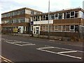
Toye, Kenning & Spencer, Newtown Road, Bedworth
This plain commercial building is home to a rare survivor of the Coventry and Bedworth ribbon weaving industry, which largely collapsed in the 1860s. Whereas Cash's in Coventry survived by specialising in woven name tapes, Toye, Kenning & Spencer make coloured ribbons, braids and laces, for products such as military medals and uniforms and masonic regalia; the company holds a royal warrant for "Supply of Gold and Silver Laces, Insignia and Embroidery", hence the royal coat of arms displayed on the building. Metalwork is made in the Jewellery Quarter in Birmingham, while the company has a shop in the west end of London.
In its present form, the company dates from 1962, but it has its origins in 1685, when the Toyé family, French Protestant refugees ('Huguenots'), arrived in London, where they set up in the textile business they had practised in France. The Toye family continues to play a part in the business, which is privately-owned. https://en.wikipedia.org/wiki/Toye,_Kenning_%26_Spencer
Image: © A J Paxton
Taken: 4 Aug 2021
0.03 miles
3
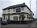
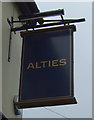
Alties public house, Bedworth
On Newtown Road.
Image: © JThomas
Taken: 11 Mar 2017
0.04 miles
4
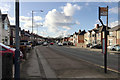
West on Newtown Road, Bedworth
It's bridged by the A444 dual carriageway in SP3486, left of centre. The space between the houses, half right, is the entrance to Bedworth Sloughs, a lake thought to be the result of mining subsidence, fed by the young River Sowe.
Image: © Robin Stott
Taken: 31 Jan 2018
0.14 miles