IMAGES TAKEN NEAR TO
Topps Heath, BEDWORTH, CV12 0DF
Introduction
This page details the photographs taken nearby to Topps Heath, CV12 0DF by members of the Geograph project.
The Geograph project started in 2005 with the aim of publishing, organising and preserving representative images for every square kilometre of Great Britain, Ireland and the Isle of Man.

There are currently over 7.5m images from over14,400 individuals and you can help contribute to the project by visiting https://www.geograph.org.uk
Image Map
Images are licensed for reuse under creativecommons.org/licenses/by-sa/2.0
Notes
- Clicking on the map will re-center to the selected point.
- The higher the marker number, the further away the image location is from the centre of the postcode.
Image Listing (18 Images Found)
Images are licensed for reuse under creativecommons.org/licenses/by-sa/2.0
Image
Details
Distance
2
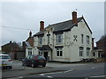
The Cross Keys, Goodyers End, Bedworth
The Cross Keys public house, or former public house, is a prominent local landmark, standing at the junction of Bowling Green Lane, Goodyers End Lane and Heath Road. It is dated 1898 on the facade. The site is now fenced off.
Image: © A J Paxton
Taken: 19 Jun 2021
0.15 miles
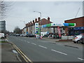
3
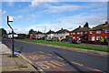
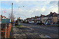
Dark Lane, Bedworth Heath
The bus stop here in an estate of mixed housing is served by one of several different routes that connect Coventry and Bedworth.
Image: © Stephen McKay
Taken: 18 Nov 2022
0.15 miles
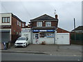
5
Service station on Heath Road, Bedworth Heath
Image: © JThomas
Taken: 11 Mar 2017
0.17 miles
6
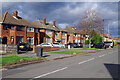
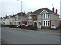
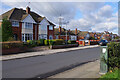
Heath Road, Bedworth Heath
A line of smart-looking semi-detached houses run along the west side of Heath Road in the outskirts of Bedworth.
Image: © Stephen McKay
Taken: 18 Nov 2022
0.17 miles
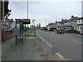
8
Goodyers End Lane, Bedworth Heath
Looking along Goodyers End Lane from close to the junction with Dark Lane. Despite the bus shelter and bus stop, regular buses do not now use this road.
Image: © Stephen McKay
Taken: 18 Nov 2022
0.18 miles
9
Dark Lane, Bedworth Heath
Dark Lane, seen here from close to the junction with Goodyers End Lane, has a mix of housing styles including the semi-detached house on the left which probably dates from the 1950s.
Image: © Stephen McKay
Taken: 18 Nov 2022
0.19 miles