IMAGES TAKEN NEAR TO
Corporation Street, COVENTRY, CV1 1PB
Introduction
This page details the photographs taken nearby to Corporation Street, CV1 1PB by members of the Geograph project.
The Geograph project started in 2005 with the aim of publishing, organising and preserving representative images for every square kilometre of Great Britain, Ireland and the Isle of Man.

There are currently over 7.5m images from over14,400 individuals and you can help contribute to the project by visiting https://www.geograph.org.uk
Image Map
Images are licensed for reuse under creativecommons.org/licenses/by-sa/2.0
Notes
- Clicking on the map will re-center to the selected point.
- The higher the marker number, the further away the image location is from the centre of the postcode.
Image Listing (993 Images Found)
Images are licensed for reuse under creativecommons.org/licenses/by-sa/2.0
Image
Details
Distance
1
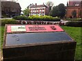
Memorial Tablet in Lidice Place
A memorial plinth displaying two tablets, situated in Lidice Place, outside the Lower Precinct. Coventry established a friendship/twinning link with the Czech village of Lidice in 1947, when representatives from Coventry attended the ceremonial laying of the foundation stone of the new village. Old Lidice had been destroyed in 1942, and most of its inhabitants executed, by the Nazi occupying forces. https://www.coventry.gov.uk/twintownsandcities This atrocity was committed in reprisal for the assassination of Reinhard Heydrich, the German governor of occupied Bohemia & Moravia, by a unit of the Czechoslovak army in exile, based in Britain. The Czech soldiers were killed resisting arrest in Prague, and are remembered by a memorial in the Jephson Gardens in Leamington, the town where they had trained. https://en.wikipedia.org/wiki/Assassination_of_Reinhard_Heydrich
Image: © A J Paxton
Taken: 1 May 2021
0.01 miles
2
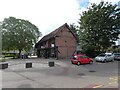
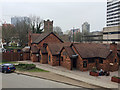
Timber-framed building on Spon Street
Restored timber-framed building on the junction of Spon Street with Corporation Street. Many buildings in this area have been moved and rebuilt from elsewhere in the city.
Image: © Gerald England
Taken: 25 Sep 2021
0.01 miles
3
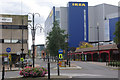
Corporation Street, Coventry
Looking into Queen Victoria Road, with Coventry's colossal IKEA showroom on the right.
Image: © Stephen McKay
Taken: 19 Oct 2008
0.01 miles
4
The view north from the six-storey Swedish shop, Victoria Road, Coventry
Corporation Street on the right; Lower Holyhead Road in the sun, upper left.
Image: © Robin Stott
Taken: 11 Jul 2016
0.01 miles
5
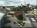
The Town Crier pub, Queen Victoria Road, Coventry
Queen Victoria Road runs behind the building, in this view from IKEA.
Image: © Robin Stott
Taken: 7 Apr 2019
0.01 miles
6
Restored timber framed building
Restored timber-framed building on the junction of Spon Street with Corporation Street. Many buildings in this area have been moved and rebuilt from elsewhere in the city.
Image: © Philip Halling
Taken: 13 Apr 2018
0.01 miles
7
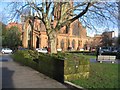
A bit of town wall
A small section of reconstituted town wall constructed on the line of wall near Spon Street. As such it is not scheduled as a monument as other parts of the city wall are.
In the background is the grade I listed 14th century church of St John the Baptist.
Image: © E Gammie
Taken: 22 Dec 2018
0.01 miles
8
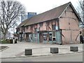
Rear of buildings on Spon Street, Coventry
Image: © habiloid
Taken: 25 Mar 2011
0.01 miles
9
![A wander around the centre of Coventry [9]](https://s3.geograph.org.uk/geophotos/07/12/27/7122763_3810aaf7_120x120.jpg)
A wander around the centre of Coventry [9]
These buildings in Fleet Street, despite appearances, seem to have been built, or, possibly, re-erected, in 1990. A plaque thereon records that the buildings were awarded the Evening Telegraph Design Award in that year. Timber framed and plastered under a tile roof.
Coventry is a large city in the West Midlands, on the River Sherbourne. It is some 16 miles southeast of Birmingham and 85 miles northwest of London. There is evidence of occupation earlier, but the present settlement grew around the abbey of St Mary, founded in 1043, and Coventry became an important medieval city. Over the centuries the principal industries have been weaving, watch making, cycle manufacturing and the production of motor vehicles. The city centre has been almost entirely rebuilt following bombing damage in WWII and includes a new cathedral built in 1962.
Image: © Michael Dibb
Taken: 25 Sep 2021
0.01 miles
10
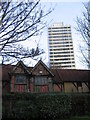
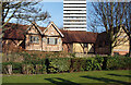
Hall houses and Mercia House
The rear of nos. 1 and 2 in the Spon Street townscape,which were formerly nos. 54-57 Spon Street and stood to the west of the ring road before being dismantled in 1973-4 and reconstructed here in 1988 and 1990. They date from the 15th century. Beyond them stands Mercia House, constructed in 1967 and currently undergoing some refurbishment which seems to include enclosing the open balconies.
Image: © E Gammie
Taken: 20 Dec 2013
0.01 miles