IMAGES TAKEN NEAR TO
Bishop Street, COVENTRY, CV1 1HU
Introduction
This page details the photographs taken nearby to Bishop Street, CV1 1HU by members of the Geograph project.
The Geograph project started in 2005 with the aim of publishing, organising and preserving representative images for every square kilometre of Great Britain, Ireland and the Isle of Man.

There are currently over 7.5m images from over14,400 individuals and you can help contribute to the project by visiting https://www.geograph.org.uk
Image Map
Images are licensed for reuse under creativecommons.org/licenses/by-sa/2.0
Notes
- Clicking on the map will re-center to the selected point.
- The higher the marker number, the further away the image location is from the centre of the postcode.
Image Listing (1212 Images Found)
Images are licensed for reuse under creativecommons.org/licenses/by-sa/2.0
Image
Details
Distance
1
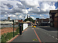
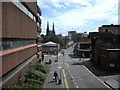
Bishop Street and two spires
A lot of tall new buildings appearing around Bishop Street but the spires of Holy Trinity and St Michael's can still be seen.
Earlier views from a similar location:
1971: Image]
1972: Image]
2016: Image]
Note that the tower block that filled the gap between the spires in 1972 and 2016 has now disappeared with its demolition in 2019.
Image: © E Gammie
Taken: 23 Dec 2019
0.00 miles
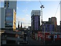
2
Tower Blocks of Coventry
Taken from Coventry Transport Museum
Image: © Geographer
Taken: 24 Sep 2021
0.01 miles
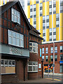
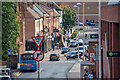
3
Bishop Street, Coventry
Looking into the city centre from the footbridge over Coventry's Ringway.
Image: © Stephen McKay
Taken: 11 Sep 2021
0.01 miles
4
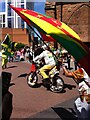
This is the City: Caribbean revels
'This is the City' was a parade through the centre of Coventry, which brought together many of the creative groups that had taken part in the 2021 UK City of Culture programme (which had been extended into 2022, after starting late in 2021 owing to the pandemic). Members of the Caribbean community can be seen here with the flags of Jamaica (left) and Grenada (centre and right foreground).
Image: © A J Paxton
Taken: 14 May 2022
0.01 miles
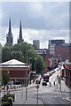
5
Downhill and south on Bishop Street, Coventry
The spires of the old cathedral and Holy Trinity Church pierce the sky on a fine summer afternoon. Bishop Street runs down to meet Corporation Street, Hales Street and The Burges. Car parks in this area are out of sight. On the left is a site to be developed by Coventry University and Barberry. To the north, behind the camera, is the Coventry Canal Basin, reached by a footbridge over the ring road.
Image: © Robin Stott
Taken: 2 Jul 2016
0.01 miles
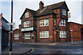
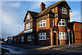
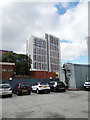
8
The Stag, Coventry
The Stag (also known as the Old Stag) is a former M&B house on the corner of Lamb Street and Bishop Street. It has fallen on hard times and is currently closed, although the pub seems to have struggled ever since it lost its major source of customers - the former Royal Mail sorting office opposite on Bishop Street - in 2010. The sorting office was only built in 1976 but has now been demolished to be replaced by Bishop Gate, seen here in the background, a block of Coventry University student accommodation that opened in 2018.
Image: © Stephen McKay
Taken: 23 Sep 2021
0.01 miles
9
Coventry-Bishop Street
Looking from the footbridge which crosses the ring road ,towards the City Centre.
Image: © Ian Rob
Taken: 29 Aug 2009
0.02 miles
10
Coventry : Bishop Street
Looking along Bishop Street.
Image: © Lewis Clarke
Taken: 25 Sep 2021
0.02 miles