IMAGES TAKEN NEAR TO
Turnberry Drive, NUNEATON, CV11 6TT
Introduction
This page details the photographs taken nearby to Turnberry Drive, CV11 6TT by members of the Geograph project.
The Geograph project started in 2005 with the aim of publishing, organising and preserving representative images for every square kilometre of Great Britain, Ireland and the Isle of Man.

There are currently over 7.5m images from over14,400 individuals and you can help contribute to the project by visiting https://www.geograph.org.uk
Image Map
Images are licensed for reuse under creativecommons.org/licenses/by-sa/2.0
Notes
- Clicking on the map will re-center to the selected point.
- The higher the marker number, the further away the image location is from the centre of the postcode.
Image Listing (15 Images Found)
Images are licensed for reuse under creativecommons.org/licenses/by-sa/2.0
Image
Details
Distance
1
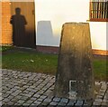
Thorn Hill Triangulation Pillar
The Thorn Hill Triangulation Pillar has been preserved and set in a cobbled area on a street corner in the middle of a modern housing estate! It is at the junction between Turnberry Drive and Hollinwell Close very near to its original location in a field.
Image: © Andrew Tatlow
Taken: 20 Nov 2021
0.06 miles
2
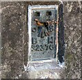
Thorn Hill Triangulation Pillar Flush Bracket
The Thorn Hill Triangulation Pillar has been preserved and set in a cobbled area on a street corner in the middle of a modern housing estate! It is at the junction between Turnberry Drive and Hollinwell Close very near to its original location in a field.
Image: © Andrew Tatlow
Taken: 20 Nov 2021
0.06 miles
3
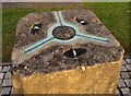
Thorn Hill Triangulation Pillar top
The Thorn Hill Triangulation Pillar has been preserved and set in a cobbled area on a street corner in the middle of a modern housing estate! It is at the junction between Turnberry Drive and Hollinwell Close very near to its original location in a field.
Image: © Andrew Tatlow
Taken: 20 Nov 2021
0.06 miles
4
Urban Trig
This trig point can remember when all around it was fields.
Image: © Michael Patterson
Taken: 12 Jun 2006
0.07 miles
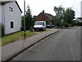
5
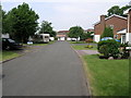
Corner Plot
This group of houses occupies the SW corner of this square. Just behind the houses on the right is a golf course.
Image: © Michael Patterson
Taken: 12 Jun 2006
0.09 miles
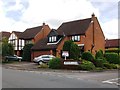
6
Housing in Foxhills Close Nuneaton
Foxhills Close is a quiet cul-de-sac on the outskirts of Nuneaton. The photograph shows modern housing typical of this area.
Image: © Peter Mackenzie
Taken: 17 Jan 2017
0.11 miles
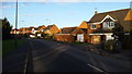
7
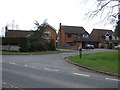
Houses in Thornhill Drive, Whitestone
At the junction with Lavenham Close. This estate was built in the 1980's on land formerly part of Thornhill Farm.
Image: © John Brightley
Taken: 5 Aug 2012
0.17 miles
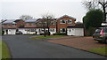
8
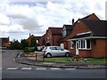
Thornhill Drive, Nuneaton
This area is on the rural fringe of Nuneaton. The area is quite prosperous and the photograph captures some of the detached dwellings typical of the district.
Image: © Peter Mackenzie
Taken: 4 Jan 2017
0.17 miles
10
Houses on Slade Close, Whitestone, Nuneaton
Image: © JThomas
Taken: 4 Mar 2017
0.21 miles