IMAGES TAKEN NEAR TO
Gloucester Close, NUNEATON, CV11 6FU
Introduction
This page details the photographs taken nearby to Gloucester Close, CV11 6FU by members of the Geograph project.
The Geograph project started in 2005 with the aim of publishing, organising and preserving representative images for every square kilometre of Great Britain, Ireland and the Isle of Man.

There are currently over 7.5m images from over14,400 individuals and you can help contribute to the project by visiting https://www.geograph.org.uk
Image Map
Images are licensed for reuse under creativecommons.org/licenses/by-sa/2.0
Notes
- Clicking on the map will re-center to the selected point.
- The higher the marker number, the further away the image location is from the centre of the postcode.
Image Listing (6 Images Found)
Images are licensed for reuse under creativecommons.org/licenses/by-sa/2.0
Image
Details
Distance
1
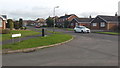
Suburban road junction
Chelsea Close at its junction with Milby Drive in the St. Nicolas Park suburb of Nuneaton.
Image: © Peter Mackenzie
Taken: 21 Feb 2017
0.08 miles
2
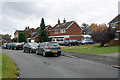
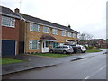
Nuneaton outer suburb
These houses, on the St Nicholas Park estate were built in 1981. The estate forms a large suburb of around one square kilometre, around two kilometres to the north-east of Nuneaton town centre.
Image: © John Rostron
Taken: 11 Oct 2009
0.16 miles
3
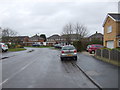
Pallett Drive, St. Nicolas Park
Looking north.
Image: © JThomas
Taken: 25 Feb 2017
0.17 miles
4
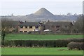
View towards Mount Jud at Camp Hill
The houses are on Norwich Close in Nuneaton. Viewed looking southwest from the A5 Watling Street.
Image: © Mat Fascione
Taken: 26 Jan 2008
0.17 miles
6
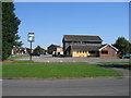
Coniston Tavern
A modern estate pub on the corner of Wallingford Avenue and Pallett Drive in the Nicolas Park area of Nuneaton.
Image: © David Stowell
Taken: 21 Sep 2006
0.22 miles