IMAGES TAKEN NEAR TO
The Rookery, NUNEATON, CV10 9PB
Introduction
This page details the photographs taken nearby to The Rookery, CV10 9PB by members of the Geograph project.
The Geograph project started in 2005 with the aim of publishing, organising and preserving representative images for every square kilometre of Great Britain, Ireland and the Isle of Man.

There are currently over 7.5m images from over14,400 individuals and you can help contribute to the project by visiting https://www.geograph.org.uk
Image Map
Images are licensed for reuse under creativecommons.org/licenses/by-sa/2.0
Notes
- Clicking on the map will re-center to the selected point.
- The higher the marker number, the further away the image location is from the centre of the postcode.
Image Listing (11 Images Found)
Images are licensed for reuse under creativecommons.org/licenses/by-sa/2.0
Image
Details
Distance
1
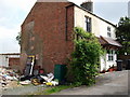
School Lane, Galley Common
According to the large scale OS plans these are numbers 6&7 School Lane.
Image: © John Brightley
Taken: 18 May 2010
0.12 miles
2
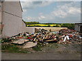
Demolition materials, School Lane, Galley Common
Adjacent to 7 School Lane.
Image: © John Brightley
Taken: 18 May 2010
0.13 miles
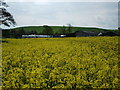
5
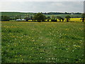
Distant view of Wood Farm
In the left background can be seen Tunnel Hill.
Image: © John Brightley
Taken: 18 May 2010
0.18 miles
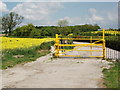
6
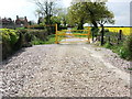
Yellow gate, School Lane
The gate appears to mark the point where the highway is downgraded from a tarmac surfaced road to an 'unclassified' county highway.
Image: © John Brightley
Taken: 18 May 2010
0.20 miles
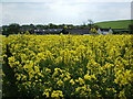
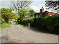
9
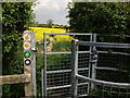
Kissing gate on Centenary Way
The footpath to the right on the other side of the gate leads to School Lane, Galley Common.
Image: © John Brightley
Taken: 18 May 2010
0.21 miles
10
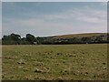
View from the Centenary Way south of Hockley
Image: © Tim Glover
Taken: 3 Aug 2003
0.21 miles