IMAGES TAKEN NEAR TO
Tulip Tree Avenue, CV10 9GU
Introduction
This page details the photographs taken nearby to Tulip Tree Avenue, CV10 9GU by members of the Geograph project.
The Geograph project started in 2005 with the aim of publishing, organising and preserving representative images for every square kilometre of Great Britain, Ireland and the Isle of Man.

There are currently over 7.5m images from over14,400 individuals and you can help contribute to the project by visiting https://www.geograph.org.uk
Image Map
Images are licensed for reuse under creativecommons.org/licenses/by-sa/2.0
Notes
- Clicking on the map will re-center to the selected point.
- The higher the marker number, the further away the image location is from the centre of the postcode.
Image Listing (7 Images Found)
Images are licensed for reuse under creativecommons.org/licenses/by-sa/2.0
Image
Details
Distance
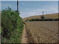
1
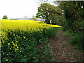
Barn Moor Wood and Wood Farm
The name of this small wood (on the right in this photo) comes from the large scale OS plans - the 1:25,000 OS maps do not name it at all.
Photo taken from the footpath which leads through the wood to Ansley.
Wood Farm in the background.
Image: © John Brightley
Taken: 18 May 2010
0.06 miles
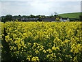
4
Distant view of Wood Farm
In the left background can be seen Tunnel Hill.
Image: © John Brightley
Taken: 18 May 2010
0.09 miles
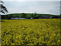
6
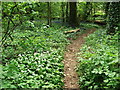
Wild garlic and bluebells, Barn Moor Wood
Image: © John Brightley
Taken: 18 May 2010
0.18 miles
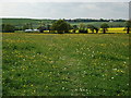
7
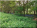
Bluebells, Barn Moor Wood
This narrow extension of the main wood is little more than a wide hedgerow, but has survived because it is a steep bank down to a stream. I have seldom seen a more dense mass of bluebells- they extended over the whole area of this narrow woodland.
Image: © John Brightley
Taken: 18 May 2010
0.22 miles