IMAGES TAKEN NEAR TO
Park Lane, NUNEATON, CV10 8LU
Introduction
This page details the photographs taken nearby to Park Lane, CV10 8LU by members of the Geograph project.
The Geograph project started in 2005 with the aim of publishing, organising and preserving representative images for every square kilometre of Great Britain, Ireland and the Isle of Man.

There are currently over 7.5m images from over14,400 individuals and you can help contribute to the project by visiting https://www.geograph.org.uk
Image Map
Images are licensed for reuse under creativecommons.org/licenses/by-sa/2.0
Notes
- Clicking on the map will re-center to the selected point.
- The higher the marker number, the further away the image location is from the centre of the postcode.
Image Listing (6 Images Found)
Images are licensed for reuse under creativecommons.org/licenses/by-sa/2.0
Image
Details
Distance
2
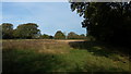
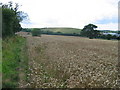
Ramble to Robinson's End
The public footpath runs along the edge of this field.
Image: © Peter Mackenzie
Taken: 30 Oct 2017
0.16 miles
3
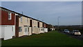
Houses in Stockingford
An example of the pre-fabricated local authority housing on Thorntons Way, Stockingford.
Image: © Peter Mackenzie
Taken: 30 Oct 2017
0.18 miles