IMAGES TAKEN NEAR TO
Leybourne Drive, MARGATE, CT9 5LQ
Introduction
This page details the photographs taken nearby to Leybourne Drive, CT9 5LQ by members of the Geograph project.
The Geograph project started in 2005 with the aim of publishing, organising and preserving representative images for every square kilometre of Great Britain, Ireland and the Isle of Man.

There are currently over 7.5m images from over14,400 individuals and you can help contribute to the project by visiting https://www.geograph.org.uk
Image Map (Loading...)


Getting Data...Please wait
Leaflet Map data © OpenStreetMap
Images are licensed for reuse under creativecommons.org/licenses/by-sa/2.0
Notes
- Clicking on the map will re-center to the selected point.
- The higher the marker number, the further away the image location is from the centre of the postcode.
Image Listing (28 Images Found)
Images are licensed for reuse under creativecommons.org/licenses/by-sa/2.0
Image
Details
Distance
1
Hussar Hotel, Garlinge
On the junction of High Street and the A28 Canterbury Road.
Image: © Nick Smith
Taken: 24 Mar 2008
0.05 miles
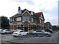
2

Garlinge Old School Hall
Hall at the junction of Dent-de-Lion Road and Garlinge High Street.
Now used as a Village Hall. With meetings of the local Women's Institute and others.
In the background is The Rodney Public House.
Image: © David Anstiss
Taken: 20 Feb 2011
0.06 miles
5
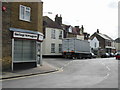
Garlinge newsagents
On the corner of High Street and Crow Hill Road
Image: © Nick Smith
Taken: 24 Mar 2008
0.07 miles
6
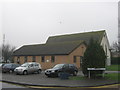
Garlinge Methodist Church
On the junction of the A28 Canterbury Road (unseen on the left) and Garlinge High Street (in the foreground).
Image: © David Anstiss
Taken: 20 Feb 2011
0.07 miles
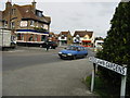
7
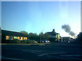
Junction of High Street Garlinge and Canterbury Road
This view is taken looking in the opposite direction to Nick Smith's Image I've no idea what or where the plume of smoke is coming from - I can only think that Manston Airport were having a fire drill, although the smoke does look a little too close to be Manston Airport. I certainly wouldn't like to speculate! That aside, the Hussar hotel is just out of shot to the right and what looks like the Garlinge Community Centre is on the left. View taken looking slightly south-southeast from Canterbury Road towards Garlinge.
Image: © Robert Lamb
Taken: 28 Oct 2008
0.07 miles
8
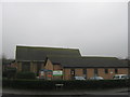
Garlinge Methodist Church (2)
On the junction of the A28 Canterbury Road (unseen on the left) and Garlinge High Street (in the foreground).
Image: © David Anstiss
Taken: 20 Feb 2011
0.08 miles
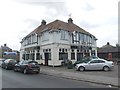
9

The Rodney Public House, Garlinge
On Garlinge High Street.
Image: © David Anstiss
Taken: 20 Feb 2011
0.08 miles
