IMAGES TAKEN NEAR TO
Chapel Mews, MARGATE, CT9 5FL
Introduction
This page details the photographs taken nearby to Chapel Mews, CT9 5FL by members of the Geograph project.
The Geograph project started in 2005 with the aim of publishing, organising and preserving representative images for every square kilometre of Great Britain, Ireland and the Isle of Man.

There are currently over 7.5m images from over14,400 individuals and you can help contribute to the project by visiting https://www.geograph.org.uk
Image Map
Images are licensed for reuse under creativecommons.org/licenses/by-sa/2.0
Notes
- Clicking on the map will re-center to the selected point.
- The higher the marker number, the further away the image location is from the centre of the postcode.
Image Listing (95 Images Found)
Images are licensed for reuse under creativecommons.org/licenses/by-sa/2.0
Image
Details
Distance
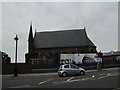
2
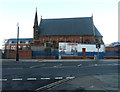
Derelict chapel, Canterbury Road
The board about Chapel Mews belongs to the estate agents Xpertagents http://www.xpertagents.co.uk/and seems to be information about the apartments, penthouses and town houses that they have for sale in the area.
Image: © John Baker
Taken: 9 Dec 2018
0.02 miles
3
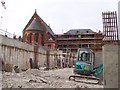
Flats under construction, 44, Canterbury Road
Planning permission was granted by Thanet District Council under application number F/TH/15/0278 for the “erection of four storey building to accommodate 13 flats with associated parking and landscaping following demolition of existing building”. My previous visit only showed the Image, which had been erected.
This was Image after building work had been completed.
Image: © John Baker
Taken: 30 Jul 2017
0.03 miles
5
Hoarding, 44, Canterbury Road
Planning permission has been granted by Thanet District Council under application number F/TH/15/0278 for the “erection of four storey building to accommodate 13 flats with associated parking and landscaping following demolition of existing building”. Chris Whippet’s Image shows the building that was demolished, after which additional hoarding seems to have been erected.
Image: © John Baker
Taken: 6 Nov 2016
0.03 miles
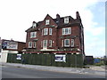
6
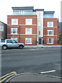
44, Canterbury Road
There are thirteen flats in this building and these were the Image
Image: © John Baker
Taken: 9 Dec 2018
0.03 miles
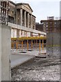
7
Construction at Royal Sea Bathing Hospital, Margate
On Canterbury Road.
New car park being built at the abandoned hospital now being turned into apartments. The red building on left of photo is an old church also turned into apartments.
Image: © David Anstiss
Taken: 17 Mar 2003
0.03 miles
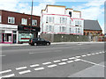
8

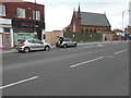
Canterbury Road
Seen from near its junction with Hartsdown Road, which is almost opposite the former Dog and Duck Hotel, which has green hoarding along its ground floor. A Google search revealed much interest in its fate.
Image: © John Baker
Taken: 8 Sep 2013
0.04 miles
9
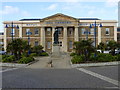
The Royal Sea Bathing Hospital, Margate
The hospital was opened in 1791, mainly for tuberculosis sufferers to experience the fresh air and to bathe in the sea water reservoir. It has now been converted into luxury apartments with an underground car park.
Image: © pam fray
Taken: 22 Feb 2014
0.04 miles
10
Construction at Royal Sea Bathing Hospital, Margate
Taken from the new underground car park at the Hospital which is being converted into apartments. On Canterbury Road.
See photo Image finished apartments, carpark under garden.
Image: © David Anstiss
Taken: 17 Mar 2003
0.04 miles