IMAGES TAKEN NEAR TO
Sloe Lane, MARGATE, CT9 4DX
Introduction
This page details the photographs taken nearby to Sloe Lane, CT9 4DX by members of the Geograph project.
The Geograph project started in 2005 with the aim of publishing, organising and preserving representative images for every square kilometre of Great Britain, Ireland and the Isle of Man.

There are currently over 7.5m images from over14,400 individuals and you can help contribute to the project by visiting https://www.geograph.org.uk
Image Map
Images are licensed for reuse under creativecommons.org/licenses/by-sa/2.0
Notes
- Clicking on the map will re-center to the selected point.
- The higher the marker number, the further away the image location is from the centre of the postcode.
Image Listing (19 Images Found)
Images are licensed for reuse under creativecommons.org/licenses/by-sa/2.0
Image
Details
Distance
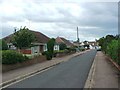
1
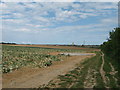
Sloe Lane (track)
This track (and footpath) leads from the A254 Ramsgate towards the A255 Dane Court. It passes a hidden underground water reservoir.
In the background is the suburbs of Cliftonville.
Image: © David Anstiss
Taken: 8 May 2011
0.02 miles
2

Sloe Lane
This track (and footpath) leads from the A254 Ramsgate towards the A255 Dane Court. Part of it is also an access road to Weddington House.
Image: © David Anstiss
Taken: 8 May 2011
0.04 miles
3
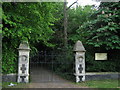
Entrance to a Pet Crematorium
As seen from a track near Ramsgate Road.
Image: © David Anstiss
Taken: 8 May 2011
0.12 miles
5
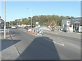
Roadworks beside Ramsgate Road (A254)
On 7 July 2014, it was reported in the Isle of Thanet Gazette that work had begun on a £4.8 million road scheme to reduce traffic congestion at Westwood Cross. Engineers and road workers from Jackson Civil Engineering Ltd were to widen Poorhole Lane, construct a shared footway for pedestrians and cyclists and to build roundabout junctions at either end of the road. This will allow some traffic to bypass the A256/A254 Westwood roundabout.http://www.thanetgazette.co.uk/Congestion-Busting-Road-Scheme/story-21338541-detail/story.html On the day of this view, Poorhole Lane was closed to traffic.
Image: © John Baker
Taken: 27 Oct 2014
0.18 miles
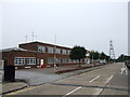
7
Margate, Hornby factory
Margate, Hornby Factory and Visitor Centre, Westwood Industrial Estate, Margate, Kent, CT9 4JX, at the corner of Ramsgate Road (A254) and Enterprise Road.
Image: © Helmut Zozmann
Taken: 1 Aug 2011
0.20 miles
10

Margate, Hornby Visitor Centre
Margate, Hornby Visitor Centre, Westwood Industrial Estate, Margate, Kent, CT9 4JX, at the corner of Ramsgate Road (A254) and Enterprise Road.
Image: © Helmut Zozmann
Taken: 4 Aug 2010
0.22 miles