IMAGES TAKEN NEAR TO
Athelstan Road, MARGATE, CT9 2BE
Introduction
This page details the photographs taken nearby to Athelstan Road, CT9 2BE by members of the Geograph project.
The Geograph project started in 2005 with the aim of publishing, organising and preserving representative images for every square kilometre of Great Britain, Ireland and the Isle of Man.

There are currently over 7.5m images from over14,400 individuals and you can help contribute to the project by visiting https://www.geograph.org.uk
Image Map
Images are licensed for reuse under creativecommons.org/licenses/by-sa/2.0
Notes
- Clicking on the map will re-center to the selected point.
- The higher the marker number, the further away the image location is from the centre of the postcode.
Image Listing (182 Images Found)
Images are licensed for reuse under creativecommons.org/licenses/by-sa/2.0
Image
Details
Distance
1
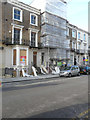
Conversion of 29, Athelstan Road
Planning permission has been granted by Thanet District Council under application number F/TH/14/0476 for a “change of use from house of multiple occupation to two, 3 bed flats and one, 2 bed flat, together with insertion of new windows and doors and formation of external stairs to side and rear elevation following demolition of existing single storey rear extension”.
Image: © John Baker
Taken: 13 Jan 2016
0.03 miles
2
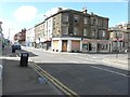
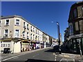
Northdown Road
Its junction with Athelstan Road is seen on the right, while opposite it is its junction with Clifton Gardens.
Image: © John Baker
Taken: 28 Jul 2013
0.04 miles
3
15, Dalby Road
Number 15 is the house with a no entry road sign on the pavement outside. This view taken when Image shows it when it was undergoing external repairs.
Image: © John Baker
Taken: 9 Dec 2018
0.05 miles
4
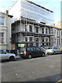
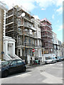
Ongoing work to 19 & 21, Athelstan Road
Number 19 is the house, whose frontage is covered with scaffolding and plastic sheeting that extends to cover the roof. It has four, 2 bedroom flats. The basement and ground floor windows, as well as the front door of number 21 have been boarded over. A sticker, that reads construction site, has been affixed to the board covering the ground floor window.
Image: © John Baker
Taken: 13 Jan 2016
0.05 miles
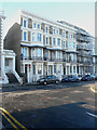
5
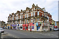
Block on Northdown Road, Margate
Built around 1900.
Image: © Robin Webster
Taken: 20 Mar 2016
0.05 miles
6
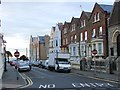
Looking NNW along Dalby Road
The house, to the left of the no entry road sign, is number 15 for which planning permission has been granted by Thanet District Council under application number F/TH/16/0619 for the “replacement of UPVC to timber windows to front elevation and re-instating original boundary railings and gate, together with external repairs”. Two doors further along the road is number 13, which appears to be undergoing a major refurbishment.
Image: © John Baker
Taken: 30 Jul 2017
0.05 miles
9

47, Northdown Road
This was a premises called Vatan, a general store dealing in Asian and European groceries, gifts, household, poundplus, toys and bags.
Image: © John Baker
Taken: 9 Dec 2018
0.06 miles
10
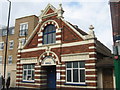
Northumberland Hall, Margate
On Northdown Road.
Image: © David Anstiss
Taken: 11 Sep 2010
0.07 miles