IMAGES TAKEN NEAR TO
Grosvenor Place, MARGATE, CT9 1UX
Introduction
This page details the photographs taken nearby to Grosvenor Place, CT9 1UX by members of the Geograph project.
The Geograph project started in 2005 with the aim of publishing, organising and preserving representative images for every square kilometre of Great Britain, Ireland and the Isle of Man.

There are currently over 7.5m images from over14,400 individuals and you can help contribute to the project by visiting https://www.geograph.org.uk
Image Map
Images are licensed for reuse under creativecommons.org/licenses/by-sa/2.0
Notes
- Clicking on the map will re-center to the selected point.
- The higher the marker number, the further away the image location is from the centre of the postcode.
Image Listing (214 Images Found)
Images are licensed for reuse under creativecommons.org/licenses/by-sa/2.0
Image
Details
Distance
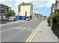
1
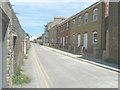
24-25A, Park Place
Last July, the houses were Image
Image: © John Baker
Taken: 22 Jun 2014
0.03 miles
2
13, Park Place
Planning permission has been granted by Thanet District Council under application number F/TH/10/0977 for the “erection of three 2 bed dwellings following demolition of existing garage, amendment to original planning permission F/TH/10/0551.
Image: © John Baker
Taken: 22 Jun 2014
0.03 miles
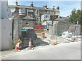
3
13, Park Place
Planning permission has been granted by Thanet District Council under application number F/TH/10/0977 for the “erection of three 2 bed dwellings following demolition of existing garage, amendment to original planning permission F/TH/10/0551.
This shows the Image when only the foundations had been laid. Now it is half-built.
Image: © John Baker
Taken: 13 Jan 2016
0.03 miles
4
Nos 24-25A, Park Place under construction
Planning permission has been granted by Thanet District Council under application number F/TH/13/0123 for the “erection of seven 2-storey dwellings following demolition of commercial building”.
Image: © John Baker
Taken: 8 Sep 2013
0.03 miles
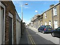
5
Subtle changes in Eaton Road
Very little has changed since my previous visit to this location along Image The tall building's render has been finished but the flats (clad in scaffolding) look the same, so one can only assume that there has been a financial crisis as far as they are concerned.
Image: © John Baker
Taken: 28 Jul 2013
0.04 miles
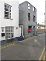
6
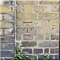
OS benchmark, High Street
Listed as 21.07m above OSDN
Image: © Keith Edkins
Taken: 23 Jun 2015
0.04 miles
7
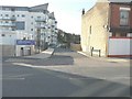
Eaton Place
This is the name of a cul-de-sac that has been constructed, off Eaton Road, to serve a new development of two blocks of flats known as Weymouth House and Stratford House (which is situated beyond Weymouth House).
Image: © John Baker
Taken: 27 Oct 2014
0.05 miles
8
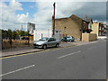
Looking WNW across Eaton Road
The square, white building, standing on the corner of Eaton Place, is a portable office, which was erected by Trading Spaces http://www.tradingspaces.co.uk/ In the distance is the block of flats known as Arlington House, partly obscured by a Ferris-wheel, located on the Dreamland site.
Image: © John Baker
Taken: 30 Jul 2017
0.05 miles
9
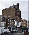
Former "Man of Kent" Hotel, High Street
The Man of Kent, built c. 1880, was originally a temperance hotel, indeed the word TEMPERANCE can still just be made out on the side brickwork. Grade II listed. See Image for doorway details.
Image: © Keith Edkins
Taken: 23 Jun 2015
0.05 miles
10
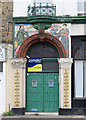
Doorway detail, the Man of Kent
Detail of Image The Chinese and Japanese figures are a reference to the origins of tea, much served in the building's original use as a temperance hotel. This is the south door, the north has a mirror image of this design.
Image: © Keith Edkins
Taken: 23 Jun 2015
0.05 miles