IMAGES TAKEN NEAR TO
Ethelbert Gardens, MARGATE, CT9 1SA
Introduction
This page details the photographs taken nearby to Ethelbert Gardens, CT9 1SA by members of the Geograph project.
The Geograph project started in 2005 with the aim of publishing, organising and preserving representative images for every square kilometre of Great Britain, Ireland and the Isle of Man.

There are currently over 7.5m images from over14,400 individuals and you can help contribute to the project by visiting https://www.geograph.org.uk
Image Map
Images are licensed for reuse under creativecommons.org/licenses/by-sa/2.0
Notes
- Clicking on the map will re-center to the selected point.
- The higher the marker number, the further away the image location is from the centre of the postcode.
Image Listing (194 Images Found)
Images are licensed for reuse under creativecommons.org/licenses/by-sa/2.0
Image
Details
Distance
1
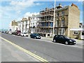
Terrace of houses, Zion Place
Scaffolding covers number 12, The Avon Hotel. Planning permission has been granted by Thanet District Council under application numbers L/TH/12/0617 for an “application for listed building consent for internal and external alterations including rebuilding of front elevation, replacement of front balcony and rear parapet” and F/TH/12/0746 for the “change of use from HMO to residential”. To its right is number 13, Clift House.
Image: © John Baker
Taken: 28 Jul 2013
0.03 miles
2
Terrace of houses, Zion Place
Number 6 is this end with scaffolding to its left. At the other end is number 12, which is the Avon Hotel; it is clad in scaffolding. Planning permission has been granted by Thanet District Council under application numbers L/TH/12/0617 for an “application for listed building consent for internal and external alterations including rebuilding of front elevation, replacement of front balcony and rear parapet” and F/TH/12/0746 for the “change of use from HMO to residential”.
Image: © John Baker
Taken: 28 Jul 2013
0.03 miles
3
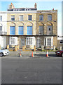
12 & 13, Zion Place
Compared with Image, when number 12’s frontage was covered with scaffolding; this view shows its present day appearance now that its restoration has been completed. Number 13, with several broken windows, appears to be derelict.
Image: © John Baker
Taken: 13 Jan 2016
0.03 miles
4
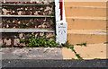
OS benchmark, Ethelbert Road
Listed as being 20.21m above OSDN
Image: © Keith Edkins
Taken: 22 Jun 2015
0.03 miles
5

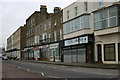
5, Zion Place
In the Image, number 5 was shown in a half finished state. Planning permission has been granted by Thanet District Council under application number F/TH/09/0364 for the “erection of two, two storey dwellings”.
Image: © John Baker
Taken: 13 Jan 2016
0.04 miles
6
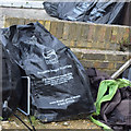
The delights of seaside living
Having seen the debris around houses which hadn't used these seagull-proof bags, I can vouch for their necessity
Image: © Keith Edkins
Taken: 22 Jun 2015
0.04 miles
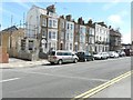
8
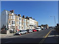
Cliff Terrace, Margate
Standing beside the B2051 road.
Image: © John Baker
Taken: 5 Sep 2012
0.05 miles
10
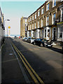
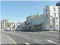
Looking northeast along Ethelbert Road
Compared with Image, the renovation of numbers 1, 3, 5 and 7 (odds) has been completed. In the distance is the obelisk of Margate’s lido.
Image: © John Baker
Taken: 13 Jan 2016
0.05 miles