IMAGES TAKEN NEAR TO
The Pier, MARGATE, CT9 1JD
Introduction
This page details the photographs taken nearby to The Pier, CT9 1JD by members of the Geograph project.
The Geograph project started in 2005 with the aim of publishing, organising and preserving representative images for every square kilometre of Great Britain, Ireland and the Isle of Man.

There are currently over 7.5m images from over14,400 individuals and you can help contribute to the project by visiting https://www.geograph.org.uk
Image Map
Images are licensed for reuse under creativecommons.org/licenses/by-sa/2.0
Notes
- Clicking on the map will re-center to the selected point.
- The higher the marker number, the further away the image location is from the centre of the postcode.
Image Listing (524 Images Found)
Images are licensed for reuse under creativecommons.org/licenses/by-sa/2.0
Image
Details
Distance
1
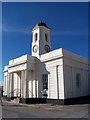
Margate Pier and Harbour Company 1812
On Margate Pier, obviously.
Image: © Richard Gadsby
Taken: 2 Jun 2009
0.00 miles
2
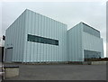
The Turner Contemporary Art Gallery, Margate
The window cleaner on the right has an unenviable job, especially in the cold wind. Viewed from The Rendezvous.
Image: © pam fray
Taken: 9 Mar 2012
0.00 miles
3
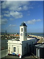
The Doirt House, Margate
Viewed from the first floor of the Turner Contemporary. Built originally for the collection of harbour dues, it now houses the Visitor Information Centre. In the background is the Stone Pier.
Image: © pam fray
Taken: 22 Feb 2014
0.00 miles
4
Harbour building
This harbour building dominates the front in Margate.
Image: © Derek Bennett
Taken: 27 Feb 2015
0.00 miles
5
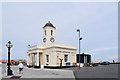
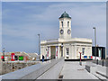
The Droit House, Margate
Droit-house n. a building at a seaport for the collection of the droits of Admiralty. Droits of Admiralty: certain rights or perquisites, as the proceeds arising from the seizure of enemies' ships, wrecks, etc., formerly belonging to the Court of Admiralty, but now paid into the Exchequer. (OED)
Although it bears the date 1812, this is a 1947 reconstruction - the original was destroyed by war-time bombing. It is now the Tourist Information Centre.
Image: © Keith Edkins
Taken: 20 Jun 2015
0.00 miles
6
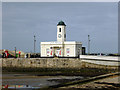
Droit House, Stone Pier, Margate
Grade II listed - 'A reconstruction after storm damage of an original building of 1812.'
Image: © Robin Webster
Taken: 20 Mar 2016
0.00 miles
7
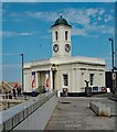
Margate : Droit House
Reconstructed in 1948 following bomb damage to the original building of 1812. Grade II listed - description at this https://historicengland.org.uk/listing/the-list/list-entry/1204115. Currently houses the visitor information centre.
Image: © Jim Osley
Taken: 11 Jul 2019
0.00 miles
8

National Cycle Network 15 Marker, Margate
Beside the information centre now housed in Image
Image: © David Anstiss
Taken: 9 Apr 2013
0.01 miles
9
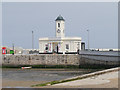
Margate Pier, The Droit House
The droit office is a post-war replica of the original building which was erected in 1830. It was destroyed by enemy bombing in 1942 and rebuilt in 1947.
It is now used by Margate's tourist information centre.
Image: © David Dixon
Taken: 16 May 2013
0.01 miles
10
Droit Office, Margate Pier
This droit office is a post-war replica of the original building which was erected in 1830. It was destroyed by enemy bombing in 1942 and rebuilt in 1947.
It is now used by Margate's tourist information centre.
Image: © David Dixon
Taken: 16 May 2013
0.01 miles