IMAGES TAKEN NEAR TO
BIRCHINGTON, CT7 9WU
Introduction
This page details the photographs taken nearby to CT7 9WU by members of the Geograph project.
The Geograph project started in 2005 with the aim of publishing, organising and preserving representative images for every square kilometre of Great Britain, Ireland and the Isle of Man.

There are currently over 7.5m images from over14,400 individuals and you can help contribute to the project by visiting https://www.geograph.org.uk
Image Map (Loading...)


Getting Data...Please wait
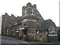
Leaflet Map data © OpenStreetMap
Images are licensed for reuse under creativecommons.org/licenses/by-sa/2.0
Notes
- Clicking on the map will re-center to the selected point.
- The higher the marker number, the further away the image location is from the centre of the postcode.
Image Listing (252 Images Found)
Images are licensed for reuse under creativecommons.org/licenses/by-sa/2.0
Image
Details
Distance
1
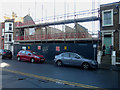
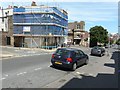
7-9, Addington Road
Planning permission has been granted by Thanet District Council under application number F/TH/17/1125 for the “erection of part three, part four storey building comprising 12 2-bed flats together with erection of rear boundary wall and single storey bin store enclosures”.
The building is being erected on a site, which used to be the premises of stonemasons Andrews and Elliott Ltd.
Image: © John Baker
Taken: 9 Dec 2018
0.02 miles
2
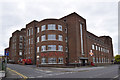
Royal Mail, Addington Road
The Margate Delivery Office
Image: © Keith Edkins
Taken: 23 Jun 2015
0.03 miles
3
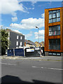
32 a & b, Addington Street
Planning permission has been granted by Thanet District Council under application number F/TH/15/0398 for the “erection of 2, three-storey dwellings following demolition of existing building”.
This is Image after construction had been completed.
Image: © John Baker
Taken: 30 Jul 2017
0.03 miles
4
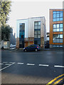
32 a & b, Addington Street
This is Image when under construction.
Image: © John Baker
Taken: 9 Dec 2018
0.03 miles
5
Looking north-northwest along Addington Street
The building encased in scaffolding and blue safety netting is number 39.
Image: © John Baker
Taken: 22 Jun 2014
0.04 miles
6
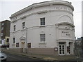
Theatre Royal, Margate
On the junction of Addington Road (in front), Princess Street (on the right) and Hawley Square (on the far left).
Grade II* Listed, built in 1787, burnt in 1829 and then remodelled in 1879.
See http://www.britishlistedbuildings.co.uk/en-356470-theatre-royal-margate for more details about the building.
See http://www.theatreroyalmargate.com/ for more current listing diary for the theatre.
Image: © David Anstiss
Taken: 20 Feb 2011
0.04 miles
7
39, Addington Street
Last June Image, you would have seen the house encased in scaffolding. Now the exterior looks very smart after its repainting.
Image: © John Baker
Taken: 27 Oct 2014
0.04 miles
8
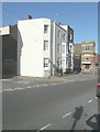
Salvation Army, Margate Citadel
This seems to be an unlisted late Victorian building, originally mapped as a Foresters' Hall.
Image: © Robin Webster
Taken: 20 Mar 2016
0.05 miles
9
The Salvation Army Citadel, Margate
On the junction of Addington Street (in front), Union Crescent (on the left) and Union Row (behind).
Image: © David Anstiss
Taken: 20 Feb 2011
0.05 miles
10
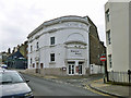
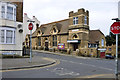
Theatre Royal, Margate
A grade II*(star) listed building from 1787, but now externally largely 19th century after a fire earlier that century.
Image: © Robin Webster
Taken: 20 Mar 2016
0.05 miles