IMAGES TAKEN NEAR TO
Ocean Close, BIRCHINGTON, CT7 9HX
Introduction
This page details the photographs taken nearby to Ocean Close, CT7 9HX by members of the Geograph project.
The Geograph project started in 2005 with the aim of publishing, organising and preserving representative images for every square kilometre of Great Britain, Ireland and the Isle of Man.

There are currently over 7.5m images from over14,400 individuals and you can help contribute to the project by visiting https://www.geograph.org.uk
Image Map (Loading...)


Getting Data...Please wait
Leaflet Map data © OpenStreetMap
Images are licensed for reuse under creativecommons.org/licenses/by-sa/2.0
Notes
- Clicking on the map will re-center to the selected point.
- The higher the marker number, the further away the image location is from the centre of the postcode.
Image Listing (47 Images Found)
Images are licensed for reuse under creativecommons.org/licenses/by-sa/2.0
Image
Details
Distance
1
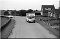
Open top bus at Epple Bay – 1972
Heading towards Minnis Bay, taken from one of its sister vehicles. In the picture is East Kent Guy Arab III FFN377, new in 1951 and converted to open top in 1969 for the coastal service. My original record simply described the location as 'Coast Road', and it took some detective work to find the exact location.
This is one of a series of views featuring buses in the 60s, 70s, and 80s. http://www.geograph.org.uk/search.php?i=137652761
Image: © Alan Murray-Rust
Taken: 5 Aug 1972
0.05 miles
2
Epple Bay Avenue
The white buildings in the distance, to the left of the road, were the temporary headquarters of Balfour Beatty Rail who were carrying out work on the Image Behind this building are the links of Westgate & Birchington Golf Course.
Image: © John Baker
Taken: 11 Dec 2013
0.05 miles
3
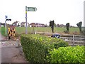
Footpath Sign to Epple Bay
Along Epple Bay Avenue, looking west.
Image: © David Anstiss
Taken: 5 Nov 2008
0.07 miles
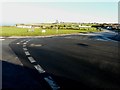
4
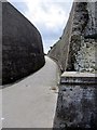
Thanet Viking Coastal Trail
The trail follows the coast along the roads and along the sea path. Here the route descents down to Epple Bay.
Image: © Oast House Archive
Taken: 24 Jun 2010
0.09 miles
6
Beacon at Epple Bay
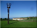
Seen from the cliff top near Birchington, Epple Bay is this side of the headland ahead. A path drops down from the road to the sea wall in the gully immediately beyond the grass on the right. The beacon was erected by the Parish Council of Birchington-on-Sea to celebrate the Diamond Jubilee of Queen Elizabeth II on 4th June 2012.
Image: © Marathon
Taken: 6 Sep 2015
0.09 miles
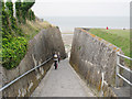
7
Alley Way
This alley leads from Epple Bay Avenue to Epple Bay, a footpath and cycle path.
Image: © Chris McAuley
Taken: 29 Jun 2012
0.09 miles
8
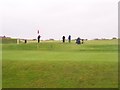
Westgate and Birchington Golf Course
On Epple Bay Avenue, that goes around the golf course to the west.
Clubhouse over in Westgate.
For more info go to http://www.westgate-and-birchington-golfclub.co.uk
Image: © David Anstiss
Taken: 5 Nov 2008
0.10 miles
9

St. James's Terrace, Birchington-on-Sea
Image: © Chris Whippet
Taken: 31 Jul 2016
0.10 miles
10
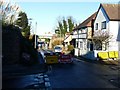
Temporarily closed railway bridge over Epple Road
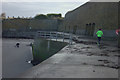
Seen from Alpha Road, the further notice on the right warned that "road closed here for bridge works from 25/11/13 for 10 weeks". The contractor for these works was Balfour Beatty Rail. There was a narrow passage for pedestrians under the bridge to enable them to reach the roads on the other side.
Image: © John Baker
Taken: 11 Dec 2013
0.10 miles