IMAGES TAKEN NEAR TO
The Retreat, BIRCHINGTON, CT7 9HS
Introduction
This page details the photographs taken nearby to The Retreat, CT7 9HS by members of the Geograph project.
The Geograph project started in 2005 with the aim of publishing, organising and preserving representative images for every square kilometre of Great Britain, Ireland and the Isle of Man.

There are currently over 7.5m images from over14,400 individuals and you can help contribute to the project by visiting https://www.geograph.org.uk
Image Map
Images are licensed for reuse under creativecommons.org/licenses/by-sa/2.0
Notes
- Clicking on the map will re-center to the selected point.
- The higher the marker number, the further away the image location is from the centre of the postcode.
Image Listing (61 Images Found)
Images are licensed for reuse under creativecommons.org/licenses/by-sa/2.0
Image
Details
Distance
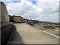
1
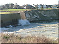
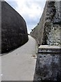
Promenade, Birchington
This appears to have been built more as a sea defence against cliff erosion than a seaside pleasure feature. It is a long way down to the sea or shore depending on the tide, with very few ways up again if you are unfortunate enough to fall over or get trapped by the tide. Chalk above and chalk below.
Image: © Robin Webster
Taken: 20 Mar 2016
0.08 miles
2
Epple Bay, slipway and Thanet Coast path
Image: © Robert Eva
Taken: 25 Jan 2018
0.08 miles
3
Epple Bay Promenade
Epple Bay Promenade part of the 27 mile Viking Coastal Trail.
http://mediafiles.thedms.co.uk/publication/tk-than/leaflet.pdf
Image: © Chris McAuley
Taken: 29 Jun 2012
0.08 miles
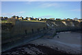
4
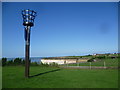
Beacon at Epple Bay
Seen from the cliff top near Birchington, Epple Bay is this side of the headland ahead. A path drops down from the road to the sea wall in the gully immediately beyond the grass on the right. The beacon was erected by the Parish Council of Birchington-on-Sea to celebrate the Diamond Jubilee of Queen Elizabeth II on 4th June 2012.
Image: © Marathon
Taken: 6 Sep 2015
0.09 miles
5
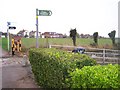
Footpath Sign to Epple Bay
Along Epple Bay Avenue, looking west.
Image: © David Anstiss
Taken: 5 Nov 2008
0.09 miles
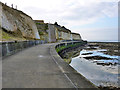
6
Thanet Viking Coastal Trail
The trail follows the coast along the roads and along the sea path. Here the route descents down to Epple Bay.
Image: © Oast House Archive
Taken: 24 Jun 2010
0.09 miles
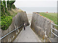
7
Alley Way
This alley leads from Epple Bay Avenue to Epple Bay, a footpath and cycle path.
Image: © Chris McAuley
Taken: 29 Jun 2012
0.09 miles
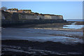
8
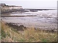
Epple Bay Seawall and lowtide beach
On cliff top, looking down at Seawall promenade which follows the steep chalk cliffs to Beresford Gap, Greenham Bay and Minnis Bay.
Image: © David Anstiss
Taken: 5 Nov 2008
0.09 miles