IMAGES TAKEN NEAR TO
Yew Tree Gardens, BIRCHINGTON, CT7 9AJ
Introduction
This page details the photographs taken nearby to Yew Tree Gardens, CT7 9AJ by members of the Geograph project.
The Geograph project started in 2005 with the aim of publishing, organising and preserving representative images for every square kilometre of Great Britain, Ireland and the Isle of Man.

There are currently over 7.5m images from over14,400 individuals and you can help contribute to the project by visiting https://www.geograph.org.uk
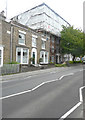
Image Map
Images are licensed for reuse under creativecommons.org/licenses/by-sa/2.0
Notes
- Clicking on the map will re-center to the selected point.
- The higher the marker number, the further away the image location is from the centre of the postcode.
Image Listing (107 Images Found)
Images are licensed for reuse under creativecommons.org/licenses/by-sa/2.0
Image
Details
Distance
1
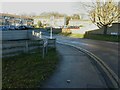
Yew Tree Gardens
A cul-de-sac accessed from Canterbury Road (A28).
Image: © John Baker
Taken: 11 Dec 2013
0.03 miles
2
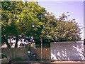
Pay and display machine in Albion Road car park
Off Albion Road is a small pay-and-display car park serving Garnett's garden centre where I pictured the old tungsten lamp post and Brills DIY centre next door. An alleyway forks just to the right of the photograph from Yew Tree Gardens off Canterbury Road, one prong of the fork leading into this car park and the other leading into the nearby park, also off Albion Road. The real reason I took this photo, however, was the floodlights that light the car park (about the only interesting things in this car park), which are rather shrouded in the tree. They are mounted on an old Stewart and Lloyd column from the 1950s, meaning an older lantern was probably installed here before the car park authority butchered the column and installed these horrible modern floodlights on it. That tree could really do with some pruning too, as the floodlights don't do a very good job at lighting the car park being so buried in it! View taken looking east-northeast.
Image: © Robert Lamb
Taken: 14 Jun 2008
0.04 miles
3
![Birchington-on-Sea buildings [2]](https://s1.geograph.org.uk/geophotos/07/06/02/7060213_3abb5a33_120x120.jpg)
Birchington-on-Sea buildings [2]
The Smugglers Restaurant at number 212 Canterbury Road was built in the late 17th century. Constructed of brown brick with red brick dressings under a tile roof with shaped Dutch gables. Listed, grade II, with details at: https://historicengland.org.uk/listing/the-list/list-entry/1203373
Birchington-on-Sea is a seaside village some 7 miles east of Herne Bay and some 3½ miles west of Margate. There is evidence of occupation from the Iron Age. As a resort, the village has a tourism based economy, with hotels, caravan parks and leisure attractions. Many retirees make the village their home.
Image: © Michael Dibb
Taken: 7 Sep 2021
0.05 miles
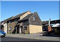
4
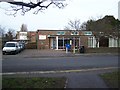
Birchington Library
On Alpha Road, close to town centre.
Image: © David Anstiss
Taken: 17 Jan 2009
0.05 miles
5
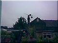
Old tungsten lamp post in Garnett's garden centre
This small garden centre on Albion Road is owned by a lady called Garnett, who also provides flowers for coffins, as well as other coffin decorations such as placards, garlands and bouquets. Sadly, the business closed down at the beginning of this year (2009) - it is currently unoccupied, but I'm sure some other business will take it over soon. Garnett now works in a trinket shop on nearby Station Road. I took this image, however, for the delightful lamp post in the garden centre (probably dating to the 1950s), which I believe is a tungsten "open" lantern (the lantern has no bowl, which allows tungsten lamps to shine freely down onto the road below). The lamp post is still standing today, despite the business' closure. View taken from the nearby car park for Brills (a DIY centre next door), looking west-southwest.
Image: © Robert Lamb
Taken: 8 Jun 2008
0.05 miles
6
![Birchington-on-Sea houses [1]](https://s0.geograph.org.uk/geophotos/07/06/02/7060212_2a3ad009_120x120.jpg)
Birchington-on-Sea houses [1]
Number 199 Canterbury Road was built in the mid 19th century. Constructed of brown brick with the roof hidden behind a parapet. There is a Doric portico. Listed, grade II, with details at: https://historicengland.org.uk/listing/the-list/list-entry/1341506
Birchington-on-Sea is a seaside village some 7 miles east of Herne Bay and some 3½ miles west of Margate. There is evidence of occupation from the Iron Age. As a resort, the village has a tourism based economy, with hotels, caravan parks and leisure attractions. Many retirees make the village their home.
Image: © Michael Dibb
Taken: 7 Sep 2021
0.06 miles
7
Mount Lavina, 195 Canterbury Road
Two planning applications were submitted to Thanet District Council. One was refused permission by the council and the other was withdrawn by the applicant.
Image: © John Baker
Taken: 10 Jun 2018
0.07 miles
8
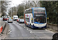
A28 at Birchington
The pedestrian crossing is closed and traffic is queuing due to roadworks on the Canterbury Road.
Image: © Martin Addison
Taken: 21 Mar 2015
0.07 miles
10
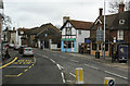
A28 at Birchington
Shops and other premises at The Square, Birchington.
Image: © Martin Addison
Taken: 21 Mar 2015
0.07 miles