IMAGES TAKEN NEAR TO
Queensdown Road, BIRCHINGTON, CT7 0HG
Introduction
This page details the photographs taken nearby to Queensdown Road, CT7 0HG by members of the Geograph project.
The Geograph project started in 2005 with the aim of publishing, organising and preserving representative images for every square kilometre of Great Britain, Ireland and the Isle of Man.

There are currently over 7.5m images from over14,400 individuals and you can help contribute to the project by visiting https://www.geograph.org.uk
Image Map (Loading...)


Getting Data...Please wait
Leaflet Map data © OpenStreetMap
Images are licensed for reuse under creativecommons.org/licenses/by-sa/2.0
Notes
- Clicking on the map will re-center to the selected point.
- The higher the marker number, the further away the image location is from the centre of the postcode.
Image Listing (9 Images Found)
Images are licensed for reuse under creativecommons.org/licenses/by-sa/2.0
Image
Details
Distance
1

Wood Church Animal Centre
Entrance to the Wood Church Animal Centre at the beginning of Queendown Road as per the map, although the road sign spelling is Queensdown Road.
http://www.geograph.org.uk/photo/3034394
Image: © Chris McAuley
Taken: 30 Jun 2012
0.20 miles

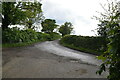
3

Queensdown Road
Queensdown Road leading onto Woodchurch Road, the map spelling of this road is Queendown Road.
Image: © Chris McAuley
Taken: 30 Jun 2012
0.22 miles
4
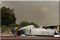
Fire Ground demonstration
Simulated aviation fuel fire on the Fire Ground at the Defence Fire Training and Development Centre, Manston https://www.gov.uk/government/publications/defence-fire-training-and-development-centre/defence-fire-training-and-development-centre shortly before the arrival of the graduates of RAF Recruit Firefighter Course 01-15
Image: © Richard Croft
Taken: 14 Aug 2015
0.24 miles
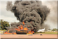
5

Fire Ground demonstration
Simulated aviation fuel fire http://www.geograph.org.uk/photo/4616035 on the Fire Ground at the Defence Fire Training and Development Centre, Manston https://www.gov.uk/government/publications/defence-fire-training-and-development-centre/defence-fire-training-and-development-centre shortly before the arrival of the graduates of RAF Recruit Firefighter Course 01-15
Image: © Richard Croft
Taken: 14 Aug 2015
0.24 miles
6
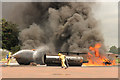
Fire Ground demonstration
Graduates of RAF Recruit Firefighter Course 01-15 demonstrate their skills in tackling a simulated aviation fuel fire http://www.geograph.org.uk/photo/4616035 http://www.geograph.org.uk/photo/4616041 at the Defence Fire Training and Development Centre, Manston https://www.gov.uk/government/publications/defence-fire-training-and-development-centre/defence-fire-training-and-development-centre
Image: © Richard Croft
Taken: 14 Aug 2015
0.24 miles
7
Fire Ground demonstration
Graduates of RAF Recruit Firefighter Course 01-15 demonstrate their skills in tackling a simulated aviation fuel fire http://www.geograph.org.uk/photo/4616035 http://www.geograph.org.uk/photo/4616041 at the Defence Fire Training and Development Centre, Manston https://www.gov.uk/government/publications/defence-fire-training-and-development-centre/defence-fire-training-and-development-centre
Image: © Richard Croft
Taken: 14 Aug 2015
0.24 miles
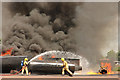
8
Fire Ground demonstration
Around three minutes after the dramatic inferno of an aviation fuel fire http://www.geograph.org.uk/photo/4616041 Graduates of RAF Recruit Firefighter Course 01-15 have everything under control at the Defence Fire Training and Development Centre, Manston https://www.gov.uk/government/publications/defence-fire-training-and-development-centre/defence-fire-training-and-development-centre
Image: © Richard Croft
Taken: 14 Aug 2015
0.24 miles