IMAGES TAKEN NEAR TO
Powell Cotton Drive, BIRCHINGTON, CT7 0BW
Introduction
This page details the photographs taken nearby to Powell Cotton Drive, CT7 0BW by members of the Geograph project.
The Geograph project started in 2005 with the aim of publishing, organising and preserving representative images for every square kilometre of Great Britain, Ireland and the Isle of Man.

There are currently over 7.5m images from over14,400 individuals and you can help contribute to the project by visiting https://www.geograph.org.uk
Image Map
Images are licensed for reuse under creativecommons.org/licenses/by-sa/2.0
Notes
- Clicking on the map will re-center to the selected point.
- The higher the marker number, the further away the image location is from the centre of the postcode.
Image Listing (35 Images Found)
Images are licensed for reuse under creativecommons.org/licenses/by-sa/2.0
Image
Details
Distance
3
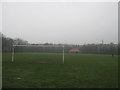
Park Road recreation ground
This small football ground is between Park Lane and Park Road.
Image: © David Anstiss
Taken: 20 Feb 2011
0.08 miles
5
Mount Lavina, 195 Canterbury Road
Two planning applications were submitted to Thanet District Council. One was refused permission by the council and the other was withdrawn by the applicant.
Image: © John Baker
Taken: 10 Jun 2018
0.16 miles
6
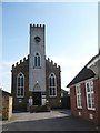
Birchington Methodist Church
The plaque on the tower reads "Methodist Chapel 1830". To the right of the picture is a building with another plaque reading "Wesleyan Schoolroom 1928".
Image: © pam fray
Taken: 22 Mar 2009
0.16 miles
7
![Birchington-on-Sea houses [1]](https://s0.geograph.org.uk/geophotos/07/06/02/7060212_2a3ad009_120x120.jpg)
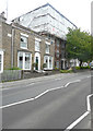
Birchington-on-Sea houses [1]
Number 199 Canterbury Road was built in the mid 19th century. Constructed of brown brick with the roof hidden behind a parapet. There is a Doric portico. Listed, grade II, with details at: https://historicengland.org.uk/listing/the-list/list-entry/1341506
Birchington-on-Sea is a seaside village some 7 miles east of Herne Bay and some 3½ miles west of Margate. There is evidence of occupation from the Iron Age. As a resort, the village has a tourism based economy, with hotels, caravan parks and leisure attractions. Many retirees make the village their home.
Image: © Michael Dibb
Taken: 7 Sep 2021
0.17 miles
8
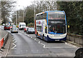
A28 at Birchington
The pedestrian crossing is closed and traffic is queuing due to roadworks on the Canterbury Road.
Image: © Martin Addison
Taken: 21 Mar 2015
0.18 miles
9
![Birchington-on-Sea buildings [1]](https://s2.geograph.org.uk/geophotos/07/06/02/7060210_b41595ec_120x120.jpg)
Birchington-on-Sea buildings [1]
Birchington Methodist Church, Canterbury Road, was built in 1830. Constructed of brick under a slate roof. Crenelated with a clock tower. Listed, grade II, with details at: https://historicengland.org.uk/listing/the-list/list-entry/1088986
Birchington-on-Sea is a seaside village some 7 miles east of Herne Bay and some 3½ miles west of Margate. There is evidence of occupation from the Iron Age. As a resort, the village has a tourism based economy, with hotels, caravan parks and leisure attractions. Many retirees make the village their home.
Image: © Michael Dibb
Taken: 7 Sep 2021
0.18 miles
10
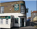
The Acorn Inn, Park Lane, Birchington
Canterbury Road can be seen in the background.
Image: © pam fray
Taken: 22 Mar 2009
0.18 miles