IMAGES TAKEN NEAR TO
Chamberlain Drive, HERNE BAY, CT6 8DH
Introduction
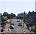
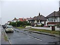
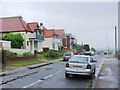
This page details the photographs taken nearby to Chamberlain Drive, CT6 8DH by members of the Geograph project.
The Geograph project started in 2005 with the aim of publishing, organising and preserving representative images for every square kilometre of Great Britain, Ireland and the Isle of Man.

There are currently over 7.5m images from over14,400 individuals and you can help contribute to the project by visiting https://www.geograph.org.uk
Image Map
Images are licensed for reuse under creativecommons.org/licenses/by-sa/2.0
Notes
- Clicking on the map will re-center to the selected point.
- The higher the marker number, the further away the image location is from the centre of the postcode.
Image Listing (134 Images Found)
Images are licensed for reuse under creativecommons.org/licenses/by-sa/2.0
Image
Details
Distance
8
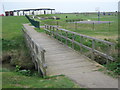
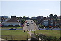
Footbridge to play area
This bridge allows parents and kids to get to a fenced play area beside Hampton Pier Avenue. The buildings in the background are a toilet block and part of a jet ski club stores. The bridge goes over a drain leading to the sea.
Image: © David Anstiss
Taken: 13 Apr 2009
0.08 miles
10
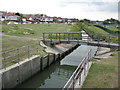
West Brook at Hampton
The brook rises 5km inland in Thornden Wood Image and comes to its outfall here alongside Hampton Pier Avenue (left). Just to the left of the photographer there is a sluice gate, presumably to keep up the water level in this section of the brook but prevent flooding. The bridge is seen from a different anlge in Image
Image: © Stephen Craven
Taken: 24 Jul 2010
0.08 miles