IMAGES TAKEN NEAR TO
Rowland Drive, HERNE BAY, CT6 7SA
Introduction
This page details the photographs taken nearby to Rowland Drive, CT6 7SA by members of the Geograph project.
The Geograph project started in 2005 with the aim of publishing, organising and preserving representative images for every square kilometre of Great Britain, Ireland and the Isle of Man.

There are currently over 7.5m images from over14,400 individuals and you can help contribute to the project by visiting https://www.geograph.org.uk
Image Map
Images are licensed for reuse under creativecommons.org/licenses/by-sa/2.0
Notes
- Clicking on the map will re-center to the selected point.
- The higher the marker number, the further away the image location is from the centre of the postcode.
Image Listing (21 Images Found)
Images are licensed for reuse under creativecommons.org/licenses/by-sa/2.0
Image
Details
Distance
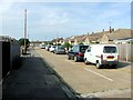
5
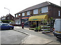
Takeaway and florist's in Greenhill
A suburban part of Herne Bay.
Image: © Jonathan Billinger
Taken: 25 Apr 2007
0.12 miles
8
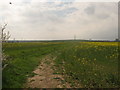
Footpath to Owl's Hatch Road
This path leads from Thornden Wood Road to a disused road. Owl's Hatch Road has been re-routed due to the construction of the A299 Dual Carriageway.
Image: © David Anstiss
Taken: 25 Apr 2010
0.15 miles