IMAGES TAKEN NEAR TO
Molehill Road, HERNE BAY, CT6 7PB
Introduction
This page details the photographs taken nearby to Molehill Road, CT6 7PB by members of the Geograph project.
The Geograph project started in 2005 with the aim of publishing, organising and preserving representative images for every square kilometre of Great Britain, Ireland and the Isle of Man.

There are currently over 7.5m images from over14,400 individuals and you can help contribute to the project by visiting https://www.geograph.org.uk
Image Map
Images are licensed for reuse under creativecommons.org/licenses/by-sa/2.0
Notes
- Clicking on the map will re-center to the selected point.
- The higher the marker number, the further away the image location is from the centre of the postcode.
Image Listing (21 Images Found)
Images are licensed for reuse under creativecommons.org/licenses/by-sa/2.0
Image
Details
Distance
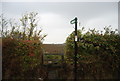
3
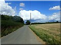
Molehill Road
The footpath on the left here, opposite the pole, leading to Maydowns Road has been re-routed compared to the OS Map which shows it starting further around the bend.
Image: © Marathon
Taken: 26 Aug 2023
0.05 miles
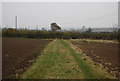
4
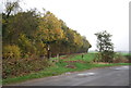
Footpath off Molehill Rd by Ash Plantation
Image: © N Chadwick
Taken: 5 Nov 2011
0.06 miles
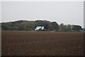
5
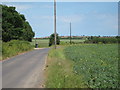
Molehill Road
Lane between Chestfield and Greenhill
Image: © Oast House Archive
Taken: 31 May 2011
0.06 miles
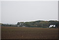
6
Footpath from Molehill Road
The footpath here which leads to Maydowns Road has been re-routed compared to the OS Map which shows it starting from Molehill Road further to the east.
Image: © Marathon
Taken: 26 Aug 2023
0.07 miles
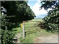
7
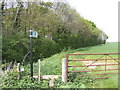
Footpath by Ash Plantation
By Molehill Road.
Image: © Jonathan Billinger
Taken: 25 Apr 2007
0.08 miles