IMAGES TAKEN NEAR TO
Hillcroft Road, HERNE BAY, CT6 7EL
Introduction
This page details the photographs taken nearby to Hillcroft Road, CT6 7EL by members of the Geograph project.
The Geograph project started in 2005 with the aim of publishing, organising and preserving representative images for every square kilometre of Great Britain, Ireland and the Isle of Man.

There are currently over 7.5m images from over14,400 individuals and you can help contribute to the project by visiting https://www.geograph.org.uk
Image Map
Images are licensed for reuse under creativecommons.org/licenses/by-sa/2.0
Notes
- Clicking on the map will re-center to the selected point.
- The higher the marker number, the further away the image location is from the centre of the postcode.
Image Listing (18 Images Found)
Images are licensed for reuse under creativecommons.org/licenses/by-sa/2.0
Image
Details
Distance
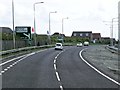
1
A299 Thanet Way
Heading West past Eddington.
Image: © Oast House Archive
Taken: 26 Oct 2009
0.06 miles
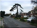
2
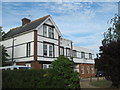
High Pines Care Home
Unusually extended house on Pigeon Lane.
Image: © David Anstiss
Taken: 30 May 2011
0.08 miles
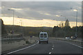
6

A299 Road, Thanet Way
Past Eddington junction with A291.
Image: © Oast House Archive
Taken: 23 Apr 2010
0.14 miles
9
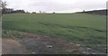
"Fifteen Acres" - A remnant of Parsonage Farm
View from the east end of Parsonage Road. This land was part of "Fifteen Acres", one of the few fields of Parsonage Farm that has survived the expansion of the new town of Herne Bay. On the 1840 Tythe Map Parsonage Farm consisted of a patchwork of fields spread between the old village of Herne Image almost down to the sea shore, then amounting to 165 acres. By the end of the 19th century the farm had been squeezed down to a few fields of cattle supplying 'The Creameries' in the town Image and by 1914 Parsonage Farm was virtually no more. See the Gallery at: http://www.geograph.org.uk/gallery/trail_of_a_kentish_farming_family_9094
(background family story http://books.google.com/books?id=hrpS_YQ9FoAC&printsec=frontcover&dq=On+Kentish+Chalk )
Image: © D Gore
Taken: Unknown
0.17 miles