IMAGES TAKEN NEAR TO
Mill Lane, HERNE BAY, CT6 7EB
Introduction
This page details the photographs taken nearby to Mill Lane, CT6 7EB by members of the Geograph project.
The Geograph project started in 2005 with the aim of publishing, organising and preserving representative images for every square kilometre of Great Britain, Ireland and the Isle of Man.

There are currently over 7.5m images from over14,400 individuals and you can help contribute to the project by visiting https://www.geograph.org.uk
Image Map
Images are licensed for reuse under creativecommons.org/licenses/by-sa/2.0
Notes
- Clicking on the map will re-center to the selected point.
- The higher the marker number, the further away the image location is from the centre of the postcode.
Image Listing (13 Images Found)
Images are licensed for reuse under creativecommons.org/licenses/by-sa/2.0
Image
Details
Distance
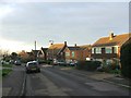
6
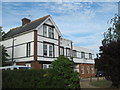
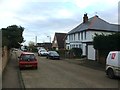
High Pines Care Home
Unusually extended house on Pigeon Lane.
Image: © David Anstiss
Taken: 30 May 2011
0.11 miles
9
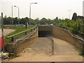
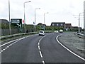
Subway under the A299 Thanet Way
Mill Lane North from the Margate Road, ends here and a subway heads under the dual carriageway heading towards Mill Lane in Hunters Forstal.
Image: © David Anstiss
Taken: 5 Jun 2010
0.20 miles