IMAGES TAKEN NEAR TO
Heart In Hand Road, HERNE BAY, CT6 7AA
Introduction
This page details the photographs taken nearby to Heart In Hand Road, CT6 7AA by members of the Geograph project.
The Geograph project started in 2005 with the aim of publishing, organising and preserving representative images for every square kilometre of Great Britain, Ireland and the Isle of Man.

There are currently over 7.5m images from over14,400 individuals and you can help contribute to the project by visiting https://www.geograph.org.uk
Image Map
Images are licensed for reuse under creativecommons.org/licenses/by-sa/2.0
Notes
- Clicking on the map will re-center to the selected point.
- The higher the marker number, the further away the image location is from the centre of the postcode.
Image Listing (4 Images Found)
Images are licensed for reuse under creativecommons.org/licenses/by-sa/2.0
Image
Details
Distance
1
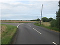
Heart in Hand Corner
Road junction near Heart in Hand Farm (in the background). Fort Hill (from Fort and Maypole) heads straight on towards Bishopstone. Margate Road heads left towards Broomfield.
Image: © David Anstiss
Taken: 8 Aug 2010
0.06 miles
2
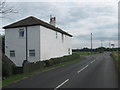
Oxenden House Farm
At Oxenden Corner, on Fort Hill leading towards Fort and Maypole.
Image: © David Anstiss
Taken: 8 Aug 2010
0.22 miles
4
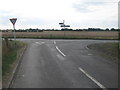
Oxenden Corner
Boyden Gate Hill (from Highstead and Boyden Gate) meets Ford Hill. Ford Hill leads right towards Bishopstone from Maypole.
Image: © David Anstiss
Taken: 8 Aug 2010
0.24 miles