IMAGES TAKEN NEAR TO
Petrel Close, HERNE BAY, CT6 6NT
Introduction
This page details the photographs taken nearby to Petrel Close, CT6 6NT by members of the Geograph project.
The Geograph project started in 2005 with the aim of publishing, organising and preserving representative images for every square kilometre of Great Britain, Ireland and the Isle of Man.

There are currently over 7.5m images from over14,400 individuals and you can help contribute to the project by visiting https://www.geograph.org.uk
Image Map
Images are licensed for reuse under creativecommons.org/licenses/by-sa/2.0
Notes
- Clicking on the map will re-center to the selected point.
- The higher the marker number, the further away the image location is from the centre of the postcode.
Image Listing (7 Images Found)
Images are licensed for reuse under creativecommons.org/licenses/by-sa/2.0
Image
Details
Distance
1
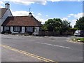
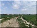
Maystreet Lane and Bogshole Lane track junction
Bogshole Lane from Broomfield meets Maystreet Lane heading left towards Bishopstone, or right towards Sweechbridge Road.
Image: © David Anstiss
Taken: 8 Aug 2010
0.16 miles
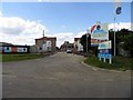
3
Hillborough Caravan Site today
This is what Hillborough Caravan Site looks like today - a housing development with a new roundabout on Reculver Road. It is almost unrecognizable from when my family and I used to spend our summer holidays here from the 70s right through to the 90s. The access road to the site is now a council-owned road called Sanderling Road and has several cul-de-sacs leading off it, whereas of course when the caravan site was opened it was simply a privately owned road and lead to a circular road surrounded by the caravans. The caravan site closed in 1998, probably because of lack of economy, as caravanning as a holiday activity has declined rapidly. I reckon even today it would've had problems in surviving, as I don't think many people could afford the rent for caravanning in these times of the credit crunch. View taken looking south-southeast towards Hillborough.
Image: © Robert Lamb
Taken: 14 Dec 2008
0.19 miles
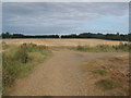
4
Beltinge Village Osborne Gardens Field
This shot was taken in the field off the back of Osborne Gardens in the Village of Beltinge. To the right of this image down a track is the railway line and on the distance to the left is the Hillborough housing estate. This view will soon be impossible as developers are building another 1,300 home estate on this field. Villagers are campaigning to build a bypass bridge near the Thanet Way to divert the mass traffic from this development away from the town.
Image: © Matt Allsop
Taken: 17 Apr 2020
0.19 miles
5
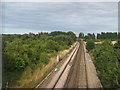
Railway to Birchington
As seen from Image
This railway leads from London (via Faversham and Herne Bay) towards Birchington and onwards to Margate and Ramsgate.
In the background is Sweech Bridge.
Image: © David Anstiss
Taken: 8 Aug 2010
0.23 miles
6
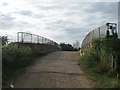
Maystreet Bridge
This track bridge over the railway leads from Maystreet Cross towards Bogshole Lane (another track).
Image: © David Anstiss
Taken: 8 Aug 2010
0.24 miles