IMAGES TAKEN NEAR TO
Mickleburgh Hill, HERNE BAY, CT6 6EF
Introduction
This page details the photographs taken nearby to Mickleburgh Hill, CT6 6EF by members of the Geograph project.
The Geograph project started in 2005 with the aim of publishing, organising and preserving representative images for every square kilometre of Great Britain, Ireland and the Isle of Man.

There are currently over 7.5m images from over14,400 individuals and you can help contribute to the project by visiting https://www.geograph.org.uk
Image Map
Images are licensed for reuse under creativecommons.org/licenses/by-sa/2.0
Notes
- Clicking on the map will re-center to the selected point.
- The higher the marker number, the further away the image location is from the centre of the postcode.
Image Listing (41 Images Found)
Images are licensed for reuse under creativecommons.org/licenses/by-sa/2.0
Image
Details
Distance
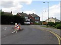
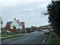
1
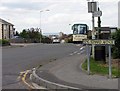
From King Edward Avenue into Mickleburgh Hill
Image: © John Salmon
Taken: 19 Jun 2008
0.02 miles
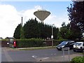
6
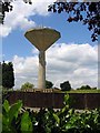
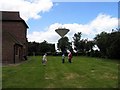
Water tower and St. Bartholomew's Church, Mickleburgh Hill
I don't think many of these water towers are still in use for their original purpose, but they make handy mobile phone masts.
Image: © Antony Dixon
Taken: 2 Feb 2012
0.04 miles