IMAGES TAKEN NEAR TO
Canterbury Road, HERNE BAY, CT6 5SE
Introduction
This page details the photographs taken nearby to Canterbury Road, CT6 5SE by members of the Geograph project.
The Geograph project started in 2005 with the aim of publishing, organising and preserving representative images for every square kilometre of Great Britain, Ireland and the Isle of Man.

There are currently over 7.5m images from over14,400 individuals and you can help contribute to the project by visiting https://www.geograph.org.uk
Image Map
Images are licensed for reuse under creativecommons.org/licenses/by-sa/2.0
Notes
- Clicking on the map will re-center to the selected point.
- The higher the marker number, the further away the image location is from the centre of the postcode.
Image Listing (38 Images Found)
Images are licensed for reuse under creativecommons.org/licenses/by-sa/2.0
Image
Details
Distance
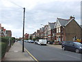
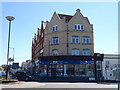
2
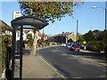
Canterbury Road, Herne Bay
Looking from the Spenser Road East northbound bus stop.
Image: © Robin Webster
Taken: 27 Oct 2017
0.03 miles

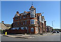
5
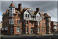
Durham House
On historic Ordnance Survey maps, this imposing building overlooking the road junction is shown as a hotel - it is currently divided into apartments.
Image: © David Martin
Taken: 18 Mar 2023
0.09 miles