IMAGES TAKEN NEAR TO
Mortimer Street, HERNE BAY, CT6 5PJ
Introduction
This page details the photographs taken nearby to Mortimer Street, CT6 5PJ by members of the Geograph project.
The Geograph project started in 2005 with the aim of publishing, organising and preserving representative images for every square kilometre of Great Britain, Ireland and the Isle of Man.

There are currently over 7.5m images from over14,400 individuals and you can help contribute to the project by visiting https://www.geograph.org.uk
Image Map
Images are licensed for reuse under creativecommons.org/licenses/by-sa/2.0
Notes
- Clicking on the map will re-center to the selected point.
- The higher the marker number, the further away the image location is from the centre of the postcode.
Image Listing (398 Images Found)
Images are licensed for reuse under creativecommons.org/licenses/by-sa/2.0
Image
Details
Distance
5
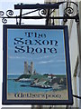
The Saxon Shore, Pub Sign
On Image
Shows a view of the coast towards the Reculver Towers.
Image: © David Anstiss
Taken: 24 Oct 2010
0.04 miles
6
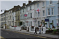
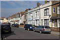
Central Parade, Herne Bay
These Victorian houses line the seafront east of Richmond Street.
Image: © Stephen McKay
Taken: 26 May 2008
0.04 miles
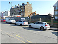
7

41, Central Parade
Planning permission has been granted by Canterbury City Council under application number CA//15/01831 for the “demolition of existing social club (us Class D2) and erection of 14 one, two and three bedroom self-contained flats (use Class C3) with 12 parking spaces and associated works”.
Image: © John Baker
Taken: 10 Sep 2017
0.04 miles
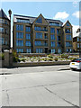
8
Redevelopment of 41, Central Parade
Planning permission has been granted by Canterbury City Council under application number CA//15/01831 for the “demolition of existing social club (use Class D2) and erection of 14 one, two and three bedroom self-contained flats (use Class C3) with 12 parking spaces and associated works”.
These were the Image after completion.
This image of Image shows the social club before it was demolished.
Image: © John Baker
Taken: 11 Mar 2018
0.04 miles
9
Flats, 41, Central Parade
This was the Image in March 2018.
Image: © John Baker
Taken: 14 Jun 2020
0.04 miles
10
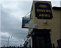
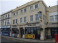
Divers Arms, Herne Bay
Displayed on the side of the building in Central Parade is a signpost stating "DID YOU REALISE? FOLLOW THIS SIGN & TIS ONLY 2675 MILES TO THE NORTH POLE".
Image: © pam fray
Taken: 2 Oct 2010
0.04 miles