IMAGES TAKEN NEAR TO
Mortimer Street, HERNE BAY, CT6 5DX
Introduction
This page details the photographs taken nearby to Mortimer Street, CT6 5DX by members of the Geograph project.
The Geograph project started in 2005 with the aim of publishing, organising and preserving representative images for every square kilometre of Great Britain, Ireland and the Isle of Man.

There are currently over 7.5m images from over14,400 individuals and you can help contribute to the project by visiting https://www.geograph.org.uk
Image Map
Images are licensed for reuse under creativecommons.org/licenses/by-sa/2.0
Notes
- Clicking on the map will re-center to the selected point.
- The higher the marker number, the further away the image location is from the centre of the postcode.
Image Listing (278 Images Found)
Images are licensed for reuse under creativecommons.org/licenses/by-sa/2.0
Image
Details
Distance
4
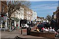
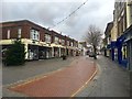
Mortimer Street, Herne Bay
Pedestrianised shopping street at the eastern end of the town centre.
Image: © Paul Harrop
Taken: 23 Sep 2015
0.03 miles
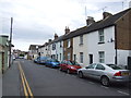
5
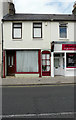
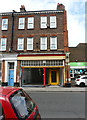
181, High Street
The house could have been a shop at one time
Image: © John Baker
Taken: 26 May 2019
0.03 miles
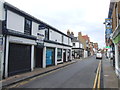
6
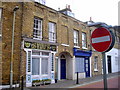
Smeeds, Smart, Signs Shop in Bank Street, Herne Bay
Image: © PAUL FARMER
Taken: 18 Jun 2011
0.03 miles

9
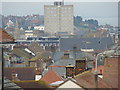
View of Herne Bay from the top of Beacon Hill
Beacon Hill rises up on the cliff top high above the sea and promenade below the cliff, giving this splendid view of Herne Bay at the top of the hill. The tower block is the one that features in Philip Perry's Image (Central Parade can just be seen running alongside it to the right of it), whilst the church spire on the left is that on the High Street. The houses on higher ground behind the tower block are on and around Central Parade as it passes Herne Bay seafront and out into Hampton. View taken looking west towards the town centre.
Image: © Robert Lamb
Taken: 14 Dec 2008
0.04 miles
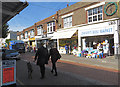
10
201, High Street
It used to be a shop called S.A.M. SPARES, which specialized in discount car parts and accessories.
Image: © John Baker
Taken: 26 May 2019
0.04 miles