IMAGES TAKEN NEAR TO
Station Approach, WHITSTABLE, CT5 1QS
Introduction
This page details the photographs taken nearby to Station Approach, CT5 1QS by members of the Geograph project.
The Geograph project started in 2005 with the aim of publishing, organising and preserving representative images for every square kilometre of Great Britain, Ireland and the Isle of Man.

There are currently over 7.5m images from over14,400 individuals and you can help contribute to the project by visiting https://www.geograph.org.uk
Image Map
Images are licensed for reuse under creativecommons.org/licenses/by-sa/2.0
Notes
- Clicking on the map will re-center to the selected point.
- The higher the marker number, the further away the image location is from the centre of the postcode.
Image Listing (141 Images Found)
Images are licensed for reuse under creativecommons.org/licenses/by-sa/2.0
Image
Details
Distance

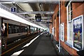
5
Whitstable station
The line between Faversham and Whitstable was opened by the Margate Railway on 1st August 1860, and was extended to Herne Bay on 13th July 1861. The first station on that line to serve Whitstable was in Oxford Street, and was known as Whitstable Town; it closed after the last train on 31st December 1914.
The following day, a new station was opened just under half a mile to the east and this was named Whitstable Town & Tankerton. The station was renamed Whitstable & Tankerton on 1st February 1936, and Whitstable in 1979.
This view is from the up platform. The next station in this direction is Faversham.
Image: © Marathon
Taken: 12 Mar 2020
0.01 miles

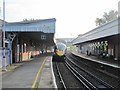
7
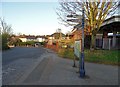
In front of Whitstable Railway Station
Image: © Neil Theasby
Taken: 24 Mar 2019
0.02 miles

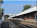
9
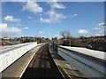
Whitstable station
The line between Faversham and Whitstable was opened by the Margate Railway on 1st August 1860, and was extended to Herne Bay on 13th July 1861. The first station on that line to serve Whitstable was in Oxford Street, and was known as Whitstable Town; it closed after the last train on 31st December 1914.
The following day, a new station was opened just under half a mile to the east and this was named Whitstable Town & Tankerton. The station was renamed Whitstable & Tankerton on 1st February 1936, and Whitstable in 1979.
This view is from the footbridge. The next station in this direction is Chestfield and Swalecliffe.
Image: © Marathon
Taken: 12 Mar 2020
0.02 miles
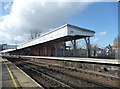
10
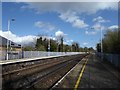
Whitstable station
The line between Faversham and Whitstable was opened by the Margate Railway on 1st August 1860, and was extended to Herne Bay on 13th July 1861. The first station on that line to serve Whitstable was in Oxford Street, and was known as Whitstable Town; it closed after the last train on 31st December 1914.
The following day, a new station was opened just under half a mile to the east and this was named Whitstable Town & Tankerton. The station was renamed Whitstable & Tankerton on 1st February 1936, and Whitstable in 1979. The Canterbury & Whitstable Railway which was said to be the first passenger railway in the world, but closed to passengers in 1931 and entirely in 1953, branched off to the right just ahead. See http://www.bbc.co.uk/kent/content/articles/2008/05/27/history_lost_railway_feature.shtml and http://www.kentpast.co.uk/Article/C__W_Railway.html
This view is from the up platform. The next station in this direction is Chestfield and Swalecliffe.
Image: © Marathon
Taken: 12 Mar 2020
0.02 miles