IMAGES TAKEN NEAR TO
Island Wall, WHITSTABLE, CT5 1EF
Introduction
This page details the photographs taken nearby to Island Wall, CT5 1EF by members of the Geograph project.
The Geograph project started in 2005 with the aim of publishing, organising and preserving representative images for every square kilometre of Great Britain, Ireland and the Isle of Man.

There are currently over 7.5m images from over14,400 individuals and you can help contribute to the project by visiting https://www.geograph.org.uk
Image Map
Images are licensed for reuse under creativecommons.org/licenses/by-sa/2.0
Notes
- Clicking on the map will re-center to the selected point.
- The higher the marker number, the further away the image location is from the centre of the postcode.
Image Listing (91 Images Found)
Images are licensed for reuse under creativecommons.org/licenses/by-sa/2.0
Image
Details
Distance
1
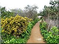
Footpath, Whitstable
By the golf course, leading to Island Wall.
Image: © pam fray
Taken: 29 Mar 2023
0.02 miles
2
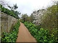
Footpath, Whitstable
Leading over the golf course to West Cliff.
Image: © pam fray
Taken: 29 Mar 2023
0.02 miles
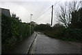
5

Golfers, Whitstable
On the Whitstable and Seasalter Golf Course.
Image: © pam fray
Taken: 29 Mar 2023
0.05 miles
6

Golfers, Whitstable
On the Whitstable and Seasalter Golf Course.
Image: © pam fray
Taken: 29 Mar 2023
0.05 miles
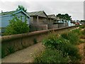
10
Saxon Shore Way on Whitstable Promenade
The long distance path heads left along the sea wall promenade towards the harbour. It also heads right. inland around a caravan and mobile home site on the coast, heading towards Seasalter.
Image: © David Anstiss
Taken: 15 Aug 2009
0.06 miles