IMAGES TAKEN NEAR TO
Bowerland Lane, CANTERBURY, CT4 8ED
Introduction
This page details the photographs taken nearby to Bowerland Lane, CT4 8ED by members of the Geograph project.
The Geograph project started in 2005 with the aim of publishing, organising and preserving representative images for every square kilometre of Great Britain, Ireland and the Isle of Man.

There are currently over 7.5m images from over14,400 individuals and you can help contribute to the project by visiting https://www.geograph.org.uk
Image Map
Images are licensed for reuse under creativecommons.org/licenses/by-sa/2.0
Notes
- Clicking on the map will re-center to the selected point.
- The higher the marker number, the further away the image location is from the centre of the postcode.
Image Listing (28 Images Found)
Images are licensed for reuse under creativecommons.org/licenses/by-sa/2.0
Image
Details
Distance
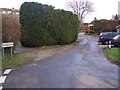
1
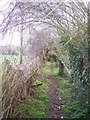
Access road to Bowerland Farm
This road leads from the A28 Canterbury Road towards the farm (in the background), then a footpath heads to Old Wives Lees.
Image: © David Anstiss
Taken: 28 Dec 2009
0.03 miles
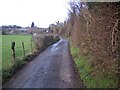
2
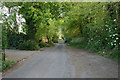
Pilgrim's Lane
This lane is a short road parallel to the A28 Canterbury Road. It later joins Shalmsford Road and then rejoins the A28.
Image: © David Anstiss
Taken: 28 Dec 2009
0.04 miles
3
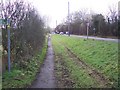
Footpath beside the A28 Canterbury Road
This path leads alongside the busy road towards Chilham. The path on the left, leads to Pickelden Lane, near the level crossing.
Image: © David Anstiss
Taken: 28 Dec 2009
0.07 miles
4
Footpath to Pickelden Lane
This path leads from the A28 Canterbury Road, near White Hill towards a cottage on the road near the level crossing.
Image: © David Anstiss
Taken: 28 Dec 2009
0.09 miles
5
Pilgrims Lane behind cottages on Canterbury Road near Shalmsford Bridge
Image: © Jacqui Sadler
Taken: 29 Apr 2007
0.10 miles
6
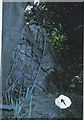
Old Milestone by the A28, Canterbury Road, Chilham
Stone post (plate lost) by the A28, in parish of Chilham (Ashford District), Canterbury Road, North of Bowland Lane, opposite house entrance, top of bank close to road edge, covered by a bush, on South side of road. Ashford marker, erected by the Faversham to Hythe & Canterbury turnpike trust in the 19th century.
Inscription once read:-
(CANTERBURY)
(5)
(ASHFORD)
(9)
Kent HER.
HER Number: TR 05 SE 151 https://www.heritagegateway.org.uk/Gateway/Results_Single.aspx?uid=MKE97691&resourceID=1005
Milestone Society National ID: KE_CYAF05
Image: © C Woodward
Taken: 2 Apr 2012
0.12 miles
7
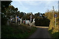
Approaching the end of Pickelden Lane, and the A28
Image: © David Long
Taken: 27 Oct 2009
0.13 miles
8
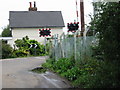
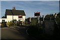
The gatekeepers cottage beside the railway line
Image: © Nick Smith
Taken: 30 Sep 2007
0.14 miles
9
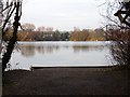
Chilham Lake
A train to Canterbury is visible on the far shore. One of the fishing points (swims) in the foreground.
This is the largest of the lakes near Chilham Mill http://www.geograph.org.uk/photo/341077 . The property is owned and managed by Mid Kent Fisheries http://www.midkentfisheries.co.uk/chilham%20mill.htm (a subsidiary of Mid Kent Water) who have developed the area for recreation and fishing. The lake, which covers 26 acres, was originally a gravel pit, dug in the late 1950s between the railway embankment and the Great Stour.
Image: © Penny Mayes
Taken: 17 Feb 2007
0.15 miles