IMAGES TAKEN NEAR TO
The Paddock, CANTERBURY, CT4 8BL
Introduction
This page details the photographs taken nearby to The Paddock, CT4 8BL by members of the Geograph project.
The Geograph project started in 2005 with the aim of publishing, organising and preserving representative images for every square kilometre of Great Britain, Ireland and the Isle of Man.

There are currently over 7.5m images from over14,400 individuals and you can help contribute to the project by visiting https://www.geograph.org.uk
Image Map
Images are licensed for reuse under creativecommons.org/licenses/by-sa/2.0
Notes
- Clicking on the map will re-center to the selected point.
- The higher the marker number, the further away the image location is from the centre of the postcode.
Image Listing (69 Images Found)
Images are licensed for reuse under creativecommons.org/licenses/by-sa/2.0
Image
Details
Distance
1
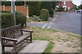
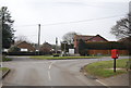
North Downs Way in Old Wives Lees
The long distance path turns down Lower Lees Road to Chartham Hatch from Long Hill and Chilham.
Image: © David Anstiss
Taken: 13 Sep 2009
0.03 miles
2
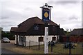
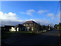
The Star Inn, Old Wives Lees
Public house on Selling Road. Note, writing on pub-sign post 'Use it or lose it', this shows the state of the village pub industry.
Image: © David Anstiss
Taken: 13 Sep 2009
0.03 miles
4
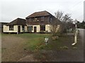
The Star Inn at Old Wives Lees
Sadly this pub is now permanently closed. See also https://www.geograph.org.uk/photo/7393533 More information about The Star inn with a list of past licensees from 1841 can be seen at http://www.dover-kent.com/Star-Chilham.html The article includes a photograph from about 1920 which shows the building on the right when it was the village shop. A group of people can be standing in the doorway which is now bricked up.
The origin of the name of Old Wives Lees is not clear but in 1870-72, John Marius Wilson's Imperial Gazetteer of England and Wales described Old Wives Lees thus: "OLD-WIVES-LEES, or Oldwoods-Lees, a place in the N E of Kent; 4¼ miles S W of Canterbury. An annual race, on 19 May, by young maids and bachelors, was instituted here by Sir D. Digges of Chilham."
Image: © Marathon
Taken: 26 Jan 2023
0.04 miles
5
The Star Inn at Old Wives Lees
Sadly this pub is now permanently closed. See also https://www.geograph.org.uk/photo/7393533 More information about The Star inn with a list of past licensees from 1841 can be seen at http://www.dover-kent.com/Star-Chilham.html The article includes a photograph from about 1920 which shows the building on the right when it was the village shop. A group of people can be standing in the doorway which is now bricked up.
The origin of the name of Old Wives Lees is not clear but in 1870-72, John Marius Wilson's Imperial Gazetteer of England and Wales described Old Wives Lees thus: "OLD-WIVES-LEES, or Oldwoods-Lees, a place in the N E of Kent; 4¼ miles S W of Canterbury. An annual race, on 19 May, by young maids and bachelors, was instituted here by Sir D. Digges of Chilham."
Image: © Marathon
Taken: 26 Jan 2023
0.04 miles
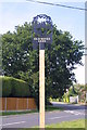
6

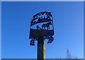
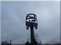
Close-up of Old Wives Lees Village Sign
A close-up photo of Image At the junction of Cobbs Hill and Long Hill.
A black metal sign showing a silhouette picture of an Oast House, a farmer with horse and plough, adorned with pears (on the left) and apples (on the right).
Image: © David Anstiss
Taken: 10 Oct 2010
0.04 miles
9
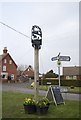
Village sign for Old Wives Lees
There is a six-way junction at the centre of Old Wives Lees. The green in the middle of the junction sees the village sign with hops and farming featuring.
The origin of the name of Old Wives Lees is not clear but in 1870-72, John Marius Wilson's Imperial Gazetteer of England and Wales described Old Wives Lees thus: "OLD-WIVES-LEES, or Oldwoods-Lees, a place in the N E of Kent; 4¼ miles S W of Canterbury. An annual race, on 19 May, by young maids and bachelors, was instituted here by Sir D. Digges of Chilham."
Image: © Marathon
Taken: 26 Jan 2023
0.04 miles
10
Village sign for Old Wives Lees
There is a six-way junction at the centre of Old Wives Lees. The green in the middle of the junction sees the village sign with hops and farming featuring.
The origin of the name of Old Wives Lees is not clear but in 1870-72, John Marius Wilson's Imperial Gazetteer of England and Wales described Old Wives Lees thus: "OLD-WIVES-LEES, or Oldwoods-Lees, a place in the N E of Kent; 4¼ miles S W of Canterbury. An annual race, on 19 May, by young maids and bachelors, was instituted here by Sir D. Digges of Chilham."
Image: © Marathon
Taken: 26 Jan 2023
0.04 miles