IMAGES TAKEN NEAR TO
Canterbury Road, CANTERBURY, CT4 8AG
Introduction
This page details the photographs taken nearby to Canterbury Road, CT4 8AG by members of the Geograph project.
The Geograph project started in 2005 with the aim of publishing, organising and preserving representative images for every square kilometre of Great Britain, Ireland and the Isle of Man.

There are currently over 7.5m images from over14,400 individuals and you can help contribute to the project by visiting https://www.geograph.org.uk
Image Map
Images are licensed for reuse under creativecommons.org/licenses/by-sa/2.0
Notes
- Clicking on the map will re-center to the selected point.
- The higher the marker number, the further away the image location is from the centre of the postcode.
Image Listing (18 Images Found)
Images are licensed for reuse under creativecommons.org/licenses/by-sa/2.0
Image
Details
Distance
3
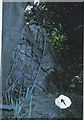
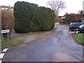
Old Milestone by the A28, Canterbury Road, Chilham
Stone post (plate lost) by the A28, in parish of Chilham (Ashford District), Canterbury Road, North of Bowland Lane, opposite house entrance, top of bank close to road edge, covered by a bush, on South side of road. Ashford marker, erected by the Faversham to Hythe & Canterbury turnpike trust in the 19th century.
Inscription once read:-
(CANTERBURY)
(5)
(ASHFORD)
(9)
Kent HER.
HER Number: TR 05 SE 151 https://www.heritagegateway.org.uk/Gateway/Results_Single.aspx?uid=MKE97691&resourceID=1005
Milestone Society National ID: KE_CYAF05
Image: © C Woodward
Taken: 2 Apr 2012
0.10 miles
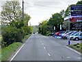
4
Pilgrims Lane behind cottages on Canterbury Road near Shalmsford Bridge
Image: © Jacqui Sadler
Taken: 29 Apr 2007
0.12 miles
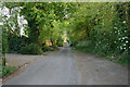
5
Pilgrim's Lane
This lane is a short road parallel to the A28 Canterbury Road. It later joins Shalmsford Road and then rejoins the A28.
Image: © David Anstiss
Taken: 28 Dec 2009
0.17 miles
6
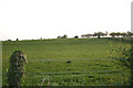
Field near Bowerland Farm and Shalmsford Bridge
Image: © Jacqui Sadler
Taken: 29 Apr 2007
0.18 miles
7
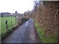
Access road to Bowerland Farm
This road leads from the A28 Canterbury Road towards the farm (in the background), then a footpath heads to Old Wives Lees.
Image: © David Anstiss
Taken: 28 Dec 2009
0.20 miles
8
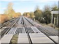
Ashford-Canterbury railway line
View north west towards Chartham, on a frosty morning.
Image: © Nigel Thompson
Taken: 17 Jan 2015
0.21 miles
9
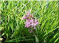
Ragged robin by the railway, near Chilham
The wetlands of the fishing lakes are nearby, a habitat favoured by the Lychnis flos-cuculi, increasingly rare as wetlands disappear. A perennial blooming from May to August.
Image: © pam fray
Taken: 13 May 2024
0.21 miles
10
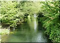
The Great Stour, Chilham
From the bridge on Pickelden Lane looking towards the railway line. The reflection in the distance is of a train passing.
Image: © pam fray
Taken: 13 May 2024
0.21 miles