IMAGES TAKEN NEAR TO
Candlers Way, CANTERBURY, CT4 7TU
Introduction
This page details the photographs taken nearby to Candlers Way, CT4 7TU by members of the Geograph project.
The Geograph project started in 2005 with the aim of publishing, organising and preserving representative images for every square kilometre of Great Britain, Ireland and the Isle of Man.

There are currently over 7.5m images from over14,400 individuals and you can help contribute to the project by visiting https://www.geograph.org.uk
Image Map
Images are licensed for reuse under creativecommons.org/licenses/by-sa/2.0
Notes
- Clicking on the map will re-center to the selected point.
- The higher the marker number, the further away the image location is from the centre of the postcode.
Image Listing (31 Images Found)
Images are licensed for reuse under creativecommons.org/licenses/by-sa/2.0
Image
Details
Distance
1
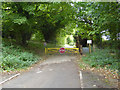
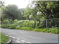
Barrier on former hospital site
The old St. Augustine's Hospital site has been redeveloped on this side of the barrier, with a great many houses, but not on the far side of the barrier. The mental hospital had a very spread-out site, and several ranges of buildings remain in a derelict state beyond the barrier. Other than the 'Stop', the only legible sign says 'Private property'.
Image: © Robin Webster
Taken: 8 Oct 2017
0.04 miles
2
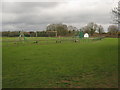
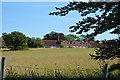
Play area beside Chartham Downs
As seen from the byway from Larkey Valley Woods to Chartham Downs Road. This play area is opposite Sycamore Close in the large housing estate beside the converted St. Augustine's Hospital.
Image: © David Anstiss
Taken: 11 Apr 2010
0.05 miles
3
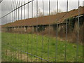
Oak House
This large disused building is part of the complex of buildings of St. Augustine's Hospital (1948-1992). This building was a specialist spinal ward. The rest of the hospital has been converted into flats and apartments, also a large housing estate surrounds the main buildings. These are on the east of the site and have been vandalised but not yet converted or demolished.
See http://www.28dayslater.co.uk/forums/showthread.php?t=48477 for more history on the hospital.
Image: © David Anstiss
Taken: 11 Apr 2010
0.08 miles
4
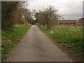
Track to Beech House School, Juniper House and Redwood House
This track leads from Updown Way to a riding school. It also leads to four disused buildings, part of the complex of buildings of St. Augustine's Hospital (1948-1992). The rest of the hospital has been converted into flats and apartments, also a large housing estate surrounds the main buildings. These are on the east of the site and have been vandalised but not yet converted or demolished. Oak House, on the right is former spinal wards.
See http://www.28dayslater.co.uk/forums/showthread.php?t=48477 for more history on the hospital.
Image: © David Anstiss
Taken: 11 Apr 2010
0.09 miles
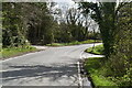
8
The Downs at the corner of Garlinge Green Road
Image: © David Howard
Taken: 12 Jun 2016
0.11 miles
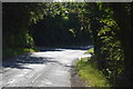
10
New housing adjacent to Chartham Downs Road
On the site of the former Chartham Hospital
Image: © Nick Smith
Taken: 30 Sep 2007
0.11 miles