IMAGES TAKEN NEAR TO
Nickle Lane, CANTERBURY, CT4 7PD
Introduction
This page details the photographs taken nearby to Nickle Lane, CT4 7PD by members of the Geograph project.
The Geograph project started in 2005 with the aim of publishing, organising and preserving representative images for every square kilometre of Great Britain, Ireland and the Isle of Man.

There are currently over 7.5m images from over14,400 individuals and you can help contribute to the project by visiting https://www.geograph.org.uk
Image Map
Images are licensed for reuse under creativecommons.org/licenses/by-sa/2.0
Notes
- Clicking on the map will re-center to the selected point.
- The higher the marker number, the further away the image location is from the centre of the postcode.
Image Listing (42 Images Found)
Images are licensed for reuse under creativecommons.org/licenses/by-sa/2.0
Image
Details
Distance

2
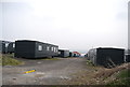
Portable housing
These are for the seasonal fruit pickers.
Image: © N Chadwick
Taken: 10 Apr 2013
0.10 miles
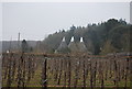
4

Portable housing
These are for the seasonal fruit pickers.
Image: © N Chadwick
Taken: 10 Apr 2013
0.11 miles


10
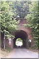
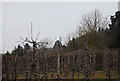
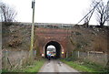
Railway bridge in Nickle Farm
Nickle Farm owns a large orchard either side of the railway. The North Downs Way (long distance path) leads under the bridge towards Chartham Hatch from Old Wives Lees. The railway heads right to Canterbury West.
Image: © David Anstiss
Taken: 13 Sep 2009
0.13 miles