IMAGES TAKEN NEAR TO
Crundale, CANTERBURY, CT4 7EJ
Introduction
This page details the photographs taken nearby to CT4 7EJ by members of the Geograph project.
The Geograph project started in 2005 with the aim of publishing, organising and preserving representative images for every square kilometre of Great Britain, Ireland and the Isle of Man.

There are currently over 7.5m images from over14,400 individuals and you can help contribute to the project by visiting https://www.geograph.org.uk
Image Map (77 Images)


Getting Data...Please wait
Leaflet Map data © OpenStreetMap
Images are licensed for reuse under creativecommons.org/licenses/by-sa/2.0
Notes
- Clicking on the map will re-center to the selected point.
- The higher the marker number, the further away the image location is from the centre of the postcode.
Image Listing (77 Images Found)
Images are licensed for reuse under creativecommons.org/licenses/by-sa/2.0
Image
Details
Distance
2
View from the byway next to Crundale Church
Image: © pam fray
Taken: 6 Apr 2010
0.06 miles
3
View across fields to Crundale church
The tower of the church ( http://www.geograph.org.uk/photo/3911 ) can just be seen in the centre of the photo.
Image: © Nick Smith
Taken: 26 Apr 2008
0.07 miles
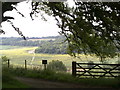
4
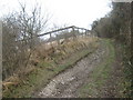
Byway to Crundale Downs lane
A byway leads from Crundale House (up the side of the Downs valley), towards a unnamed lane near St. Mary's Church.
Image: © David Anstiss
Taken: 21 Mar 2010
0.07 miles
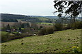
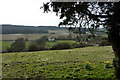
6
View of the downs from Crundale Church
Crundale Church marks a point where various routes meet including paths and byways.
Image: © Peter S
Taken: 6 Jul 2013
0.07 miles
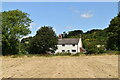
7
Crundale House, near Crundale
Viewed from the byway next to Crundale Church.
Image: © pam fray
Taken: 6 Apr 2010
0.07 miles
8
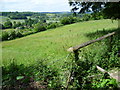
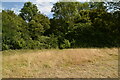
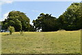
Crundale Downs
John Newman in Pevsner's The Buildings of England North East and East Kent says of Crundale: "Crundale is in the remotest and most glorious downland of the whole county. The church stands alone, and so do the few houses dotted through the parish." On a glorious longest day of the year it is hard to disagree with these sentiments.
This view is from a downland byway which leads to Crundale Church a short distance ahead. Most of the hamlet of Crundale is in the valley to the left.
Image: © Marathon
Taken: 21 Jun 2015
0.08 miles
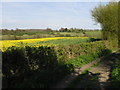
10
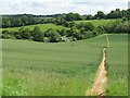
Path through the cereal field
Some of the paths in Crundale are overgrown and difficult to navigate but there is doubt as to the path through this cereal field.
Image: © David M Clark
Taken: 9 Jun 2024
0.08 miles