IMAGES TAKEN NEAR TO
Ashford Road, CANTERBURY, CT4 7DH
Introduction
This page details the photographs taken nearby to Ashford Road, CT4 7DH by members of the Geograph project.
The Geograph project started in 2005 with the aim of publishing, organising and preserving representative images for every square kilometre of Great Britain, Ireland and the Isle of Man.

There are currently over 7.5m images from over14,400 individuals and you can help contribute to the project by visiting https://www.geograph.org.uk
Image Map
Images are licensed for reuse under creativecommons.org/licenses/by-sa/2.0
Notes
- Clicking on the map will re-center to the selected point.
- The higher the marker number, the further away the image location is from the centre of the postcode.
Image Listing (37 Images Found)
Images are licensed for reuse under creativecommons.org/licenses/by-sa/2.0
Image
Details
Distance
2
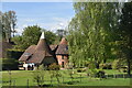
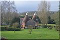
Path through East Stour Farm
A footpath leaves the A28 to pass through the delightful East Stour Farm here and under the railway line of 1846. The stations on either side are Wye and Chilham.
Image: © Marathon
Taken: 31 Aug 2013
0.02 miles
3
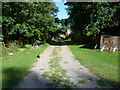
Farm track under railway bridge at East Stour Farm
Image: © Jacqui Sadler
Taken: 29 Apr 2007
0.03 miles
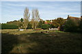
4
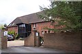
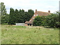
East Stour Farm Barn
Near East Stour Farm, on the A28 Ashford Road.
Image: © David Anstiss
Taken: 13 Sep 2009
0.03 miles
5
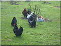
Cat among the chickens
Neither the cat nor the chickens seemed worried by the others' presence at East Stour Farm.
Image: © Marathon
Taken: 9 Feb 2014
0.03 miles
6
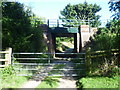
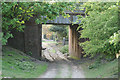
Railway bridge at East Stour Farm
A footpath leaves the A28 to pass through East Stour Farm here and under the railway line of 1846. The stations on either side are Wye and Chilham. Further up ahead the path meets the Stour Valley Walk.
It was a rather different scene here six months later after two months of rain - see http://www.geograph.org.uk/photo/3844420
Image: © Marathon
Taken: 31 Aug 2013
0.03 miles
8
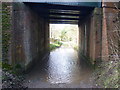
Underneath the railway bridge at East Stour Farm
A footpath leaves the A28 to pass through East Stour Farm here and under the railway line of 1846. The stations on either side are Wye and Chilham. Just behind, the path meets the Stour Valley Walk. This is the view looking back to the farm and to the A28. Wellington boots were very necessary here in contrast to six months earlier at the end of a long hot summer - http://www.geograph.org.uk/photo/3634060
Image: © Marathon
Taken: 9 Feb 2014
0.04 miles
10
East Stour Farm house
Just by the A28 south of Chilham.
Image: © Jonathan Billinger
Taken: 27 Jun 2007
0.04 miles